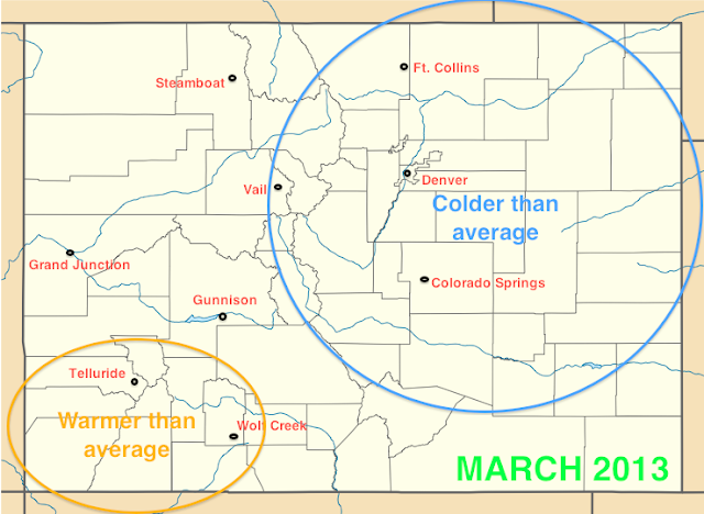
March 2013 temperatures compared to average
March 2013 snowfall/precipitation compared to average
Colder, snowier than average March for northeast Colorado; drier than average for southern and western Colorado
Compared to last year's excessively warm and dry March statewide, Front Range residents experienced a much more typical March this year, with temperatures in Denver actually ending up below average and precipitation and snowfall ending up above average. This is good news for drought conditions, although it's only a small dent in a larger problem. Unfortunately, much of the state also experienced below average precipitation aside from Denver, northeast Colorado, and parts of the northern/central mountains.
Four separate accumulating snowfall events occurred in Denver and northeast Colorado during March, amounting to 23.5" total for the month at DIA, which is nearly double the average. A light snow event occurred on March 4, bringing a couple of inches to most of the metro area. A more significant storm affected northeast Colorado several days later, on March 9, but the storm underperformed, bringing 4-6" of wet snow to Denver instead of the 8-14" that was forecasted. A few days later, a secondary system arrived, bringing a surprise 3-5" to the city on the morning of March 12.
Warmer weather arrived on the 13th, bringing above average temperatures to Denver for the next five days, including a record high of 76 degrees on the 15th. However, the biggest snowstorm of the season for the Mile High City hit on the evening of the 22nd lasting through the afternoon of the 23rd, dropping 11.7" of snow in Denver and bringing unseasonably cold temperatures for the next few days. Temperatures on the 22-24 were more than 25 degrees below average as highs were only in the 20's for all three days. On the 23rd, the low temperature at DIA reached 2 degrees, which was just shy of a record low for the day. Milder weather returned during the final days of March, as high temperatures in the 60's quickly melted the snow. Denver finished March with an average temperature 2.7 degrees below average, while 1.47 inches of precipitation fell, which is 0.55 inches above average.
For the northern and central mountains, above average snow fell for the Central Front Range, including Loveland and Berthoud Passes, and Summit County, while near average snow fell for the Northern Front Range. Farther west, areas from Vail up to Steamboat actually experienced below average snowfall, unlike prior months when Steamboat was outperforming most other areas of Colorado.
In the southern and western mountains, below average snowfall and slightly above average temperatures were the rule, as most of the storms to hit Colorado in March favored the northern ranges and/or the Front Range. Southeastern Colorado also was much drier than normal, including Colorado Springs and Pueblo, where precipitation was at least three quarters of an inch below average for most areas, which is unfortunate news for this drought-plagued region, especially considering March is typically one of the wettest months. Most of the storms the hit Colorado this March did not provide much precipitation south of the Palmer Divide, which is why Denver and points northeast received much more moisture.
Cool, unsettled on Tuesday... Denver could wake up to wet snow
A low pressure system moving into Colorado from Utah is producing precipitation across the state, with light rain falling in Denver as of 11:00 pm Monday night, and rain/snow showers expected into the morning hours. Temperatures will fall to near freezing overnight, so wet snow showers and light accumulations on grassy surfaces will be possible by daybreak Tuesday morning. Temperatures will reach the high 40's to low 50's as the clouds gradually break later in the day. Cooler temperatures will be found in the foothills as well as out on the northeastern plains, so an inch or two of snow accumulation will be possible for these areas.
The low pressure system is bringing plentiful moisture and unstable air to the mountains, with moderate snow accumulations expected in the high mountains on Tuesday, with relatively high snow levels during the day (9,000 to 10,000 ft.). The precipitation will be convective in nature, so thunder and lightning could accompany many of the heavier snow showers. Depending on where the heaviest snow showers occur, some of the ski areas could see good accumulations, although skiers, snowboarders, and other outdoor enthusiasts should be wary of lightning in the afternoon, especially above treeline.
Warmer, drier weather returns on Wednesday and lasts through the end of the week
A ridge of high pressure moves into Colorado on Wednesday, bringing gradually clearing skies and more seasonal temperatures. By Thursday and Friday, temperatures will be above average again, with Friday expected to be the warmest day, especially in the Front Range urban corridor where downsloping winds off the mountains could push temperatures into the 70's, before temperatures cool off a little on Saturday.
Stormy weather pattern could return early next week
This is still almost a week away, but models are hinting at a dip in the jet stream by Sunday/Monday of next week, and a potentially significant storm system moving into Colorado which could bring good snow to the mountains.


No comments:
Post a Comment