NWS Denver/Boulder Watches and Warnings
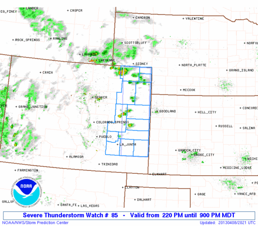
A major spring storm system is moving into Colorado, bringing all sorts of extreme weather. Temperatures have already reached 70 degrees, but a remarkable temperature swing is going to occur very soon. Ahead of the main system, warm air, moisture, and instability have allowed thunderstorms to pop up across eastern Colorado. In fact, a Severe Thunderstorm Watch is in effect for most of Eastern Colorado (from Limon east) and the first Severe Thunderstorm Warning of the year for Colorado has been issued for Kit Carson County. Large hail and lightning are going to be the main severe weather threats this afternoon, with strong winds and isolated tornadoes also a possibility. Amazingly enough, many of the same areas of northeastern Colorado that are included in the Severe Thunderstorm Watch are also under a Winter Storm Warning! It's pretty rare for this to occur simultaneously over the same area.
Severe Thunderstorm Watch Box and Radar Image
Radar image of severe thunderstorm near the town of Stratton
Around 6:00 or 7:00 this evening, a strong cold front associated with the storm will move south through the Denver metro area. Gusty winds will switch from southerly to north-northeasterly, and a dramatic fall in temperatures will occur. In fact, after topping 70 degrees at DIA today, the Front Range metro area is going to experience a 50 degree temperature drop over a 12 hour period! The picture below shows thickness values of the air (thicker air = warmer temperatures), which gives a good idea of temperature trends. In most parts of the country, the 5400 meter thickness line is generally the cut-off for the rain/snow line or freezing level, but in the higher elevations of the mountain west around Denver, the 5520 line is used to determine rain/snow line. Regardless, you can see how close together the colder lines are over southern Wyoming (as of recent), indicating a cold surge working its way south toward Colorado.
A sharp dip in the thickness levels over Wyoming indicate the approximate location of the cold front
Upslope rain showers will develop within an hour or two of the frontal passage, and as temperatures plummet, rain will change over to snow between 10 pm and midnight. Snow will be heavy at times overnight, and winds will be gusty as well, creating blizzard conditions for some areas... in fact Blizzard Warnings are in effect from Pueblo to Colorado Springs to Castle Rock. There is still some uncertainty as to where the heaviest snow will fall in the Front Range... the storm track is still trending fairly far to the north, meaning the heaviest accumulations will fall in eastern Wyoming, western Nebraska, and the Dakotas. However, the Front Range metro area should still be in line for good snow accumulations... just not as much as originally thought a day or two ago
The Front Range metro area from Denver to Boulder to Ft. Collins can expect 5-9 inches of snow total, with the highest amounts farther north towards Ft. Collins. Areas from Colorado Springs to Pueblo will only see 2-6 inches, with most of the energy centered farther north, but strong winds will create blizzard conditions for this region. The Front Range foothills should the most snowfall, with 8-16 inches likely for areas at and above 7,000 feet. For the mountains, areas along and west of the Divide will see less snowfall due to an unfavorable wind direction from the east, but plentiful moisture and storm energy could still produce some heavy bands with spotty accumulations. The notable exception will be in the San Juan Range, Sangre de Christo Range, and the eastern sides of the Sawatch and Mosquito Ranges, all of which could see a foot or more of snow. The image below shows abundant moisture at an altitude of about 10,000 feet (700 millibar pressure level) moving into Colorado, as of 4:00 pm local time.
The storm will hang around through Tuesday evening before snowfall tapers off across the Front Range. Unseasonably cold temperatures will be present tomorrow, with daytime temperatures struggling to stay above 20 degrees in Denver... yes you read that right, after a daytime temperature of 70 today, daytime temperatures tomorrow will be about 20 (if not colder). Temperatures on Tuesday night will fall into the single digits, potentially reaching record levels. Skies will slowly clear on Wednesday, but high temperatures will be nearly 30 degrees below average.


No comments:
Post a Comment