Just when you thought we couldn't possibly see anymore spring snowfall events in the Denver area (especially following a weekend of 75-80 degree temperatures)... it's going to happen again... this time on May 1st.
A deep and powerful low pressure trough is diving southward toward Colorado as we speak, bringing with it another blast of unseasonably cold air and upslope precipitation. Denver is going to see snow fall for most of the day Wednesday, but I don't think the city will receive nearly as much snow accumulation as what the National Weather Service and other outlets are predicting (more on that below).
Several days of warm and sunny weather concluded yesterday with a high of 80F in Denver, before an initial cold front ahead of the main system moved through early this morning, bringing much cooler weather today (temps are currently in the mid to upper 50's across the metro area). The cold front moved through earlier than what models were forecasting, making me think the main cold front will reach our area earlier tonight as well, meaning perhaps an earlier onset of snowfall after precipitation starts out as rain.
This system is going to produce substantial precipitation once again for Northern Colorado, which is nothing but good news as our spring weather pattern continues to put a dent in the drought (excluding Southern Colorado, which has been MUCH drier than Northern Colorado this spring). As for snowfall, the Front Range foothills and mountains, as well as the northern I-25 corridor from Ft. Collins to Cheyenne, should receive the heaviest amounts, with up to a foot possible in the foothills, and up to 20" possible for areas in Rocky Mountain National Park, the Cameron Pass region, and the Indian Peaks. Even though the areas along and east of the Continental Divide will be favored for upslope snow, a band of heavy snow associated with the system will set up across Northern Colorado, providing good snowfall totals for areas west of the Divide as well, such as the Park Range/Steamboat, Gore Range, Vail, and Summit County.
In Denver, the NWS has issued a Winter Weather Advisory for 4-7" of snow in the city proper, but I believe we have too many factors working against us to see this much snow. The best snow-producing conditions are going to exist during the daytime hours tomorrow, but that doesn't mean we'll see good snow-accumulation conditions, despite what the models are showing. The surface is going to be very warm following several days of 70+ degree temperatures, and it's also May 1st tomorrow, meaning of course that solar radiation is very strong at this time of year... because of this, I do not think we will see much accumulation during the daytime hours, even though temperatures will be near freezing at daybreak and gradually falling into the upper 20's by the afternoon (yes, WAY below average for the first of May).
I do think the cold front and subsequent changeover to snow will occur earlier than what models are forecasting, though, likely in the overnight hours... so I think there's a good chance Denver could wake up to 2-3" of wet snow by daybreak, but given the recent warmth and marginal freezing temps at the start of the event, I'm willing to bet the roads will remain snow-free in the city. Once the sun is up, however, I think the warm surface and strong solar radiation will prevent much snow from accumulating. The only way I really see these factors being overcome is if a band of very heavy snow sets up over Denver, and heavy snowfall rates are able to accumulate snow faster than surface conditions are able to melt the snow, and while this is possible, I'm not willing to bet on it given the unpredictable nature of these heavy snow bands in spring time snow events such as this (where snowfall accumulations can vary significantly over short distances).
Looking outside of Denver, I do think that areas on the western side of the metro area, at slightly higher elevations, could see noticeably more snowfall than Denver, due in part to enhanced precipitation rates from the upslope effect of higher terrain, as well as relatively less surface heating from being farther removed from the urban heat island effect of central Denver, where more concrete surfaces can trap and hold more heat, when compared to grassy surfaces (it's a localized effect, but can sometimes make a difference in these type of situations).
I believe Denver will see 2-4" of snow overall (most occurring overnight tonight, and perhaps a little more in the late afternoon/evening hours tomorrow), and even this may be a little high, while I'm more confident western metro cities from Boulder to Arvada to Golden will see 4-8". I also think Ft. Collins will fall into the 4-8" range (maybe on the lower end of the range, though), as the region close to the Wyoming border will see the colder air and precipitation move in sooner tonight, and heavier bands of snow could set up overnight as well. In the foothills west of the metro area and up to the Continental Divide, 8-15" will be possible, especially above 7,000 ft., and I wouldn't be surprised to see some totals in the 18-24" range in Rocky Mountain National Park.
Snowfall should wind down tomorrow evening, and depending on how quickly the skies clear, record low temperatures will be in jeopardy once again (I believe the record low for the date in Denver is around 22-23F). Denver's all time record low for the month of May is 19F, and it is not out of the question we could reach this mark, although I think we'll come up a few degrees shy of that mark. Sunshine returns on Thursday, quickly melting whatever snow is on the ground in Denver, but temperatures will only reach the mid to upper 40's... still about 20 degrees below average.
Northerly flow will continue through the weekend as the low pressure system stalls to the east of us, so slightly unsettled and chilly weather will continue... with highs in Denver topping out in the mid to upper 50's this weekend, with scattered clouds and rain chances possible, along with some snow showers in the mountains. Models are not in great agreement about this weekend in regards to precipitation, though, so all I can say for now is that we might see some rain, or even some thunderstorm chances, but I am pretty confident that the metro area will not see snow this weekend.
We have had a remarkable spring in terms of snowfall this year, which has many people complaining of course, but we need to put things in perspective... last spring was a disaster, with almost no snow and precipitation, and as a result we quickly fell into a drought situation and suffered through a devastating wildfire season. For most of the winter, the drought continued, and the situation heading into the spring did not look good for our snowpack or our water resources... this spring has basically been a miracle for northern Colorado, with our mountain snowpack (in northern and central CO at least) rebounding to near normal for this time of year (less than peak average, but normal for late April), after being well below normal all winter long, and the amount of moisture Denver and the Front Range have received in March and especially April have been enough to put a huge dent into our drought, and will help replenish our water resources and lower our wildfire danger this summer... not to mention, it will "green up" the landscape this spring and into early/mid summer. So keep these things in mind if/when you catch yourself complaining about the snow tomorrow... more spring snow just means that much better of a summer.
Tuesday, April 30, 2013
Monday, April 29, 2013
Quick Monday Morning Update
Last night's forecast is still on track, with temperatures approaching 80F under clear skies today, before a strong system brings a chance of snow to the region on Wednesday. The timing of the cold air punch doesn't look ideal for Denver to receive much accumulation, however... I think snow will fall, but temperatures will be near to above freezing during the day Wednesday for much of the event, which combined with a high sun angle at this time of year, won't be conducive for accumulation. The foothills and mountains could receive more significant totals, however.
I made a post on my Facebook page this morning regarding May snowfall in Denver (since Wed is May 1st), and wanted to repost it below. Also, here is a very interesting and informative article written by the NWS Denver/Boulder office about our pattern of spring storms this year.
http://www.crh.noaa.gov/images/bou/showimages/Explanation_for_%20Recent_Big_Snowfalls.pdf
Post about May snowfall...
Regarding the forecast for snow on May 1st... snow in May in Denver is not unusual. In fact, the city averages 1.7" of the white stuff in May, and saw accumulating snowfall in May in 2010 and 2011. Significant snow events in May are rare in Denver, but they have happened before... the biggest single storm snow total ever in May was 12.4" in 1978.
The cold air punch for our upcoming storm is looking a little weaker this morning, so I don't think we'll see much accumulation from this storm... but do expect snow to fall during the day Wednesday, and much colder temperatures after highs push 80F today.

Sunday, April 28, 2013
Colorado enjoys warm temperatures, sunny skies; but once again, changes (yes, SNOW) are looming
Sorry for the short updates, but the end of the semester has left me little time with finals coming up, school projects, new job, etc.
We've (finally) enjoyed our warmest stretch of weather so far this season in Colorado, with bluebird skies and temperatures well into the 70's on both Saturday and Sunday. We'll have one more day of nice, mild weather on Monday, with highs likely reaching 80 for many parts of the metro area.
However, just when you thought we couldn't possibly get anymore spring snowfall in the Denver area... it's going to happen again, and on May 1st. Tuesday night, a deep trough of low pressure and associated strong upper level jet will dip south into Colorado, bringing a surge of colder air and precipitation behind it, mainly affecting eastern Colorado along and east of the Continental Divide. A strong cold front associated with the low pressure system will move through on Tuesday afternoon/evening, bringing a quick drop in temperatures, gusty winds, and the onset of precipitation beginning as rain, then changing over to snow at night (how many times have we seen this scenario this spring?).
A few models are indicating 1-2" of precipitation across the Front Range (from the metro area to the Continental Divide), which is awesome news, as our parade of spring storms continue to put a damper on the drought. We are getting into May, and following a stretch of very warm weather, so I still don't think we'll see significant snow accumulations in Denver like we've seen with recent storms, but I do think a few inches of wet snow overnight are very possible... mostly on grassy surfaces, but possibly creating slick roads by daybreak. The foothills and mountains could see significant accumulations, however, with up to a foot possible... great news for water resources, snowpack, and for Loveland and A-Basin, which are still open and enjoying excellent late season skiing conditions.
Temperatures on the first day of May (Wednesday) will be 30+ degrees below average in Denver, and unfortunately for those of you who were spoiled by this weekend's weather, below normal temperatures will persist through the weekend as surges of cooler air and moisture from the north continue to pool into Colorado. By late this week and into next weekend, we'll likely see high temperatures in the 50's in Denver, which is warmer than Wednesday, but still pretty chilly for early May, as weak disturbances continue to move through, possibly bringing a few rain showers to the metro area, but more likely bringing periodic snow showers to the mountains, which certainly wouldn't be a bad thing for Loveland's closing weekend!
Tuesday, April 23, 2013
Warmer weather finally set to arrive
Another short update tonight...
A warm-up is finally on the way, though, along with sunshine. Highs tomorrow in Denver will be around 50... on Thursday and Friday, we'll be in the mid 60's... and on Saturday and Sunday we'll be in the upper 60's to low 70's.
From earlier Tuesday...
Mountain snowfall totals (estimates based on 12:1 snow to liquid ratio) from the latest storm include...
18" Buffalo Pass (Steamboat)
17" Arrow site (Indian Peaks)
15.5" University Camp (Indian Peaks)
15.5" Wild Basin (RMNP)
14.5" Berthoud Pass
13" A-Basin (official ski area report)
13" Bear Lake (RMNP)
11" Loveland Ski Area (official ski area report)
11" Copper Mountain
11" Elliott Ridge (Gore Range)
9.5" Cameron Pass
Also, the parade of spring storms has pushed the seasonal snowfall total in Denver up to 73.5" (average is 57.5"), which surpasses the big winter of 2006-2007, when 72.6" fell. While Denver's official weather records have changed locations over the years and aren't entirely reliable, as it now stands, 2012-2013 is officially the snowiest winter in Denver since 1991-1992! Pretty amazing considering how dry early to mid winter was.
Denver also set it's 4th record low temperature of April 2013 last night, when the temp fell to 21F just before midnight.
Monday, April 22, 2013
Another April storm bringing heavy snow to Denver once again... more seasonal weather to finally arrive later in the week

NWS radar image showing a band of heavy snow parked over the Denver area at 10:00 pm Monday night
Another extremely busy week at a crazy time of year has left me with little time to update the blog, so on nights like this, I will repost my shortened forecasts and updates that I post more frequently on the blog's Facebook page... especially since the weather pattern continues to be extremely active for Colorado.
Monday night update...
Impressive late season snow storm continues for much of Colorado. It's snowing very heavily in Denver right now, with a snow band currently parked over the area. Accumulations could pile up quickly at this rate, and I'm now expecting 4-7" for Denver by Tuesday morning when things wind down, and 6-10" for the southern and western parts of the metro area, including Boulder, Golden, Arvada, Littleton, and Highlands Ranch.
The mountains have and continue to be hit with heavy snow as well, with some SNOTEL sites indicating double digit totals in the last 24 hours (and it's not over yet)... heaviest snow so far has been in the Park Range (Steamboat) and Front Range, including the foothills, Berthoud Pass, the Indian Peaks, RMNP, and Cameron Pass. Loveland and A-Basin should ski very well tomorrow, although as evidenced by last weekend's tragedy on Loveland Pass, avalanche conditions continue to be less than ideal for backcountry skiers and snowboarders.
If you're tired of the cold and snow, then hang in there, because I have good news. Tomorrow will feature one last unseasonably cold day, but changes are on the way following a cold start to Wednesday morning. Temperatures warm into the low 50's on Wednesday in Denver (an improvement, but still chilly for late April), before shooting up to more seasonal levels on Thursday and beyond... by Saturday and Sunday, we could see highs reach the low 70's!
Sunday, April 21, 2013
Looking back at a busy week, including heavy snow and Colorado's deadliest avalanche in 50 years. Active weather pattern to continue

Excellent late season riding conditions at Loveland Ski Area
I haven't posted in a while due to a very busy time at school, along with night events and ski days, so it's time to catch up after an extremely active weak weather-wise. A series of spring storms brought a foot of snow to parts of Denver last Monday, boosted to the mountain snowpack significantly, and unfortunately, led to Colorado's deadliest avalanche in 50 years yesterday, up on Loveland Pass. I've been posting updates on my blogs facebook page throughout the past week, so I'll include a summary of those below (scroll down lower if you want to see the current forecast and summary)...
Monday April 15 (morning)...
Closing day (for most ski areas) was a big powder day across Colorado! Sat night/Sun morning totals include... 15" Beaver Creek... 14" Monarch... 13" Copper Mtn and Vail... 12" Loveland, Silverton, Aspen, Breck, Eldora... 11" Aspen Highlands... 10" Winter Park and Snowmass
Another round of heavy snow began last night in the mountains and continues today, with Loveland reporting an additional 8" on their morning snow report! Heaviest snow today will fall in the north, including Steamboat and the Front Range mountains... while Vail/Summit County should also do well. It's going to be an active week with more heavy snow likely on Wednesday.
For the foothills and plains... Heaviest snow through Tuesday morning will fall farther north, including the Ft. Collins area up to Cheyenne (6-10"), as well as the Front Range foothills from Nederland to Estes Park. Denver will be a little too far south of the action and will see just a mix of rain and snow showers today, with light accumulation possible overnight (colder air and more snow possible on Wed, though). Boulder will get more than Denver but less than Ft. Collins... likely in the 3-7" range.
Monday April 15 (afternoon)...
Well, missed that forecast for Denver. Heavy snow amounted to 7" in Boulder this morning while Denver had virtually nothing. However, the snow band dropped just far enough south this afternoon, and it has been snowing very heavily in Denver over the last 3 hours. Downtown we already have about 5" I'm guessing
Tuesday April 16...
Heavy snow yesterday afternoon/evening amounted to 10-15" (about a foot near downtown Denver) from central Denver to Boulder to Ft. Collins, with nearly two feet in Estes Park. Snow came to an end overnight, with fog and freezing drizzle hanging around this morning. A few snow showers possible this afternoon, then a surge of cold air and another round of snow arrive on Wednesday.
The mountains got slammed yesterday as well. 24 hour ski resort totals include 15" at Loveland and 12" at Winter Park. And since Saturday night... Loveland has seen 35" and Winter Park 29"! SNOTEL sites indicate many areas from Aspen to Vail/Summit and especially the Front Range mountains picked up 15-20" yesterday! It might be mid April, but these are the best skiing conditions of the season (for places that are still open anyways). The moisture is also great news for our depleted water sources, as well as for the upcoming wildfire season.
The mountains got slammed yesterday as well. 24 hour ski resort totals include 15" at Loveland and 12" at Winter Park. And since Saturday night... Loveland has seen 35" and Winter Park 29"! SNOTEL sites indicate many areas from Aspen to Vail/Summit and especially the Front Range mountains picked up 15-20" yesterday! It might be mid April, but these are the best skiing conditions of the season (for places that are still open anyways). The moisture is also great news for our depleted water sources, as well as for the upcoming wildfire season.
Wednesday April 17 (morning)...
Winter in April continues... believe it or not, more snow is on the way for Denver. Precipitation may start out as freezing drizzle overnight into Wednesday morning (enough to ice over your windshields), then the cold front passes through by mid morning, bringing falling temps (into the low-mid 20's by afternoon), snow, and wind...
Denver and Boulder should see 4-8", with 6-14" possible in the foothills and Palmer Divide, and lower amounts around Ft. Collins. With the sporadic nature of this springtime snow event, accumulations may vary widely across short distances, depending on where the heaviest bands set up.
Relatively warmer weather returns on Friday, but temperatures look to remain well below average for at least the next week.
Mountains will see moderate to heavy snow on Wednesday as well, and again on Friday night and Saturday, which is good news for the final weekend at Winter Park and Aspen Highlands, as well as at Copper Mtn and Vail, which both announced today that they are re-opening for the weekend!
Wednesday April 17 (afternoon)...
It's snowing steadily in Denver, but not really accumulating yet even though the temp is in the upper 20's. The snow will have to pick up in intensity (or temps continue to drop, which is very possible) to overcome the high mid April sun angle to really begin to accumulate, like what happened on Monday. One of the many reasons forecasting these Front Range spring snowstorms can be such a challenge. I'm a little more skeptical about that 4-8" at this point, but as we saw on Monday, a burst of heavy, wet snow can pile up very quickly. Higher elevations (foothills, mountains, Palmer Divide, etc.) outside of the city should still see good snowfall.
Thursday April 18...
This morning, the temp at DIA fell to 9F. This ties for the latest date a single digit temp has ever officially been reported in Denver! In addition, DIA has now recorded 70" of snow this season (compared to an average of 58.5"), which is pretty amazing considering that on Feb 15 we had only had 17" to date.
How long will the unseasonably cold weather last? Unfortunately for warm weather lovers, about another week. Relatively warmer temperatures tomorrow through Sunday, along with another decent shot of snow for the mountains on Saturday. Then, unseasonably cold and unsettled weather returns early next week, bringing more snow to the mountains, and yes, believe it or not, another chance of snow for Denver.
Looking long range... more seasonal temperatures may FINALLY return by Friday/Saturday of next week (the 26th/27th). Until then, think on the bright side... we've been in a drought and the late season snows have been and continue to be hugely beneficial for our water resources, and will also reduce wildfire danger this summer (notice I said reduce, not eliminate). Also, skiing/snowboarding conditions over the past week are the best they've been in two years.
The mountain snowpack in northern Colorado has made an impressive comeback this spring, and is more than twice as deep compared to this time last year!

Northern Colorado snowpack as of April 18
Weekly summary in pictures

Copper Mountain's closing day (prior to its reopening) on April 14 was it's biggest 24-hr snow day of the season, with 13" falling overnight, making for an excellent powder day

Heavy snow falls in downtown Denver on the evening of Monday, April 15

Much of Denver woke up to nearly a foot of heavy, wet snow along with slick roads on Tues, April 16

Heavy snowfall throughout the week led to some amazing spring skiing conditions at Loveland Ski Area on April 20... unfortunately it also contributed to conditions responsible for a devastating avalanche accident on Loveland Pass the same afternoon
Current conditions and forecasts...
Avalanche kills five backcountry snowboarders on Loveland Pass
The heavy spring snows in the mountains have been beneficial in many ways, but have also created some very dangerous late season avalanche conditions... earlier in the week, a backcountry snowboarder was killed in an avalanche near Vail Pass. And then, yesterday, a large avalanche near Loveland pass took the lives of five experienced backcountry snowboarders... an awfully tragic situation, and the deadliest avalanche in Colorado since 1962. Due to the recent heavy snows coupled with persistent weak layers in the snowpack that formed during extended early winter droughts in November/early December and again in January, avalanche danger is significantly higher than usual for this late in the season, and is very much in a winter-like state even though the calendar says spring. The Colorado Avalanche Center is extending its daily forecasts for another week, through April 28, and is an extremely valuable resource for anyone traveling in the backcountry.
Brief break in an active weather pattern brings sunny skies and more seasonal temperatures Sunday
The most recent spring system brought several inches of snow to the mountains and scattered rain showers to the Denver area on Saturday, but in its wake, a brief period of high pressure has made for a pleasant Sunday, with seasonal temperatures, mostly sunny skies, and light winds. High clouds are already on the increase, though, ahead of the next low pressure system approaching Colorado... which looks to bring one last blast of winter.
Next system to bring yet another round of April snow to Denver
The unseasonably cold and snowy April will resume on Monday, as yet another low pressure system moves through Colorado, bringing snow to many areas as the upper level jet stream sits atop the state. The northern and central mountains will begin to see snow overnight Sunday into Monday morning, lasting through the day with moderate snow totals possible. As often is the case in the spring, the heaviest accumulations will depend on exactly where the heaviest bands set up... during the day it looks like areas from Vail Pass to Aspen/Independence Pass to Monarch Pass could see some of the highest totals during the day, with the Front Range mountains picking up a significant amount through Tuesday morning.
A few rain and snow showers will spread out into the foothills and plains as well, although temperatures across the Denver area will be mild on Monday morning. A cold front associated with the system will move through, however, and in the afternoon, winds will switch to northeasterly (upslope) and precipitation will begin across the Front Range metro area and foothills... starting in the northern foothills and Ft. Collins area, before spreading south later in the afternoon. Precipitation could start as rain, but falling temperatures will allow for a quick changeover to snow.
Snow will continue into the night hours, with 2-4" likely in the Denver area, but 3-6" (or more) possible in the southern and western sides of the metro area, and even more is likely in the foothills above 7,000 ft. The snow will mostly be over by Tuesday morning, and the high sun angle will quickly melt any snow off of the roads, but unseasonably cold temperatures will be left in its wake, with highs in Denver in the 30's on Tuesday, dropping into the upper teens Tuesday night.
The trough associated with the low pressure system moves south on Tuesday, bringing snow to Colorado Springs, Pueblo, and Walsenburg, with models indicating some very heavy snow totals for the Sangre de Christo Mountains and Wet Mountain Range, and good moisture across southeast Colorado. While northeast Colorado has seen extremely beneficial moisture this spring, southern and southeast Colorado is still suffering from a major drought, so this storm would be welcome news to the area.
More seasonal temperatures return to Denver later in the week, while periods of snow continue in the mountains
A period of northwest flow will commence across Colorado on Wednesday and Thursday (and perhaps beyond), bringing continued rounds of snow to the northern and central mountains, will Denver and eastern plains experience a warming and drying trend... finally! Temperatures rebound into the 50's after a cold start on Wednesday, and by the weekend will reach seasonal levels in the mid 60's under mostly sunny skies. In other words, it's going to feel like spring for the first time in quite a while for the Mile High City (currently, we stand a good chance of this month ending up as one of the top 5 coldest Aprils in Denver's recorded history).
In the mountains, decent snow accumulations will be possible on Wednesday and Thursday, mainly for the higher elevations, since temperatures will be warmer (more seasonal) compared to recent. Models are in disagreement over what happens next weekend, but snow showers will be possible once again Friday into next Saturday... looks like a classic spring set-up for most of the period with scattered snow showers interspersed with sunshine, and mostly light winds... not a bad thing.
Saturday, April 13, 2013
Major storm to dump heavy snow in the mountains overhight; extended period of unseasonably cold, unsettled, and snowy weather on tap for both the mountains and the Denver metro area this weekrea

WRF Model snow projections through noon Tuesday
Significant storm to bring closing day powder to many ski areas
Today has been the warmest day statewide since the past week of cold and unsettled weather, which saw Denver break three record lows (record low max of 22F on the 9th, record low of 9F on the 9th, record low of 6F on the 10th). Accompanying the warm temperatures, however, were the winds ahead of the incoming system... gusty winds east of the mountains, and very strong winds for the higher elevations.
A strong disturbance with an associated upper level jet streak (which enhances upward motion, and thus strongly enhances precipitation) is moving into Colorado from due west tonight, and is going to bring heavy snow to most of the major mountain ranges and ski areas, minus the Southern San Juans and Sangre de Christos. The Front Range mountains, Summit County, Gore Range Vail/Beaver Creek, Steamboat, Flat Tops, Aspen/Crested Butte, and the Northern San Juans are all in line for big snow Saturday night through Sunday morning, with some areas likely picking up a foot or more. Many areas are closing tomorrow, and they will be closing on a high note with an excellent powder day in store (and with it being April, less crowds than usual for a weekend day).
A few rain and snow showers for Denver and the Plains overnight into Sunday morning
As a cold front moving in from the Pacific (west) associated with the mountain snow storm reaches the Front Range urban region overnight, scattered rain and snow showers will develop across the northeastern plains, but nothing significant of note, with mostly dry but mostly cloudy conditions being prevalent across the metro area on Sunday. After a comfortable day with highs in the 60's on Saturday, temperatures will cool off 10-15 degrees across the metro area on Sunday, only reaching the low to mid 50's... however, much colder air is expected for the upcoming week.
Farther south, high winds are expected to develop across Colorado Springs, Pikes Peak, Pueblo, the Wet Mountains, and the Sangre de Christo Mountains. Gusts of 65 mph will be possible below 7,500 feet, with hurricane force gusts expected for the higher terrain, such as Pikes Peak.
Significant period of very active and unseasonably cold weather in store for Colorado this week
Dry conditions will return following the storm on Sunday, with the sun briefly coming out later in the afternoon in the mountains. However, a major storm cycle is set to begin overnight Sunday, as the upper level trough and associated jet stream max (otherwise known as a jet streak) park itself over Colorado for several days. A significant amount of moisture is expected to develop with this system, along with shots of unseasonably cold air for mid April.
The forecast is fairly complicated as to who will get the most snow and when exactly, but as of right now, periods of moderate to heavy snow are likely to develop in the mountains again overnight Sunday, and continuing through Wednesday night. A stronger cold front will also be arriving Sunday night, bringing much colder air to the state. Highs in Denver will only reach 40 or so on Monday, and it will be even colder by midweek. Upslope precipitation is expected to begin Monday night and continue through the day Wednesday. The extent of moisture and wind direction are still in question, but models are hinting at an extended period of snow for Denver from Monday night through Wednesday... a long enough period that significant snow totals will be possible. Highs on Tuesday and Wednesday will be 30-35 degrees below average in the city, with record challenging cold possible again on Wednesday night.
Drier conditions return to the Front Range metro area on Thursday, but below average temperatures will continue through next weekend. Northwest flow could develop late next week and into next weekend, which could bring additional snow to the northern and central mountains, but this is still a ways in the future.
The details for next week aren't totally clear yet, but it's going to be an active and interesting system to follow, with significant snowfall accumulations possible for many parts of the state... this would be great news for water resources as we head into spring and summer.
Tuesday, April 9, 2013
Storm Update: Modest snow totals, but blizzard-like conditions and exceptional cold
The April 8-9 storm system in Colorado will not be remembered for its big snow totals... but will be for its extreme weather conditions, including a remarkable temperature drop, strong winds, tornadoes, and record cold.
Temperatures were very warm across the region yesterday afternoon, with highs reaching 70 for many. The cold front moved through, bringing a dramatic temperature drop, with severe weather occurring in northeast CO ahead of the front. A dry slot occurred overnight in Denver (the thunderstorms out east "stole" some of our moisture), so the snow really didn't start picking up until this morning. I forecasted less snow than the NWS... originally called for 4-7" for Denver, then upped it to 5-9". I think my original forecast is going to end up being correct. Additionally, as I mentioned yesterday, the mountains west of the Divide (except for the San Juans farther south) are not getting much snow because of an unfavorable wind direction despite what many weather services predicted. It always surprises me how the major weather service outlets, including the NWS, always predict heavy snow for the ski areas west of the Divide with these types of systems, despite the obvious fact that an unfavorable wind direction associated with an upslope snow event will leave them in a "snow shadow".
Anyways, here are some highlights of weather extremes from the system so far...
- When the cold front first reached Colorado from the north, the temp in Greeley fell from 70F to 49F in about 10 minutes! Simply incredible.

Weather graph for Greeley shows an incredible temperature drop at the frontal passage, along with a shift in wind direction from southeast to north
- Between 4 pm yesterday and 6 am this morning, the temp in Denver plummeted from 71F to 15F (56 degree drop!), including a fall from 68F to 50F between 5 and 6 pm, and the first snow flakes started to fall by 9 pm. See the chart below. The temperature in Denver is currently 14F, with sustained winds of 25 mph and a wind chill of -5F. For some perspective, the average high temp in Denver for April 6 is 61F. Temperatures up on Loveland and Berthoud Passes, both above 11,000 ft., have fallen to 0F. The cold air has had trouble crossing the Continental Divide to the west, so temperatures in places such as Gunnison, Aspen, and Vail are nearly 20 degrees warmer than in Denver and northeastern CO (see second image below).

Weather data at Denver International Airport, showing a dramatic temperature drop from 71F to 15F in 14 hours

Surface map showing temperature in red, dewpoint below, and wind speed/direction. Notice the temperature differences between northeast CO and western CO
- The record low max temp for today is 27F... we're guaranteed to break that, since it was 22F by midnight, and has only fallen since then. The record low today is 12, so we will probably break that too... tomorrow's record low is 7, which we could also tie or break in the morning. After tomorrow... April 11, 12, and 18 are the last remaining days in the month with record lows in the single digits, which gives some perspective on how cold this system is for this time of year.
- Last but not least, is the severe weather element that occurred with this system. Severe thunderstorms fired up across eastern Colorado yesterday afternoon and evening, with four reports of tornadoes touching down. One tornado occurred near the town of Akron, damaging three buildings and destroying a mobile home. I don't know if this is confirmed, but amazingly, I heard a report that snow may have occurred with the tornado-producing storm near Akron! The tornado-producing storms occurred around dusk as the sharp cold front was moving through.

Strong to severe thunderstorms to the northeast of Denver yesterday evening... the red boxes indicate tornado warnings

Tornado-producing storm moving over Akron at about 9:00 pm

Image showing a sharp contrast in temperatures as the front moved toward the southeast at 8:00 pm last night... notice the nearly 30 degree temp difference between Denver and Limon
What to expect in the days following the storm...
Temperatures will remain well below average for the next few days across northeast CO... After near record low temperatures in the single digits to start Wednesday morning, temperatures will warm into the low to mid 30's across the urban region... still nearly 30 degrees below average.
A weak system will move through the mountains behind the main system, bringing a round of snow showers to the northern and central mountains. A second round of snow should occur on Thursday as well. Temperatures in Denver on Thursday will warm to around 50 (still chilly for April), but a weather disturbance moving through that evening will bring a chance of rain and snow showers to the city overnight... likely nothing significant, though. Still some uncertainty regarding the details of weather for the upcoming weekend and early next week, but in general, the weather pattern looks active with good snow chances for the mountains and continued below average temperatures for the Denver region.
Monday, April 8, 2013
Spring Storm Approaching Colorado: Winter Storm Warnings for much of Colorado, Severe Thunderstorm Watch for Eastern Colorado

NWS Denver/Boulder Watches and Warnings
A major spring storm system is moving into Colorado, bringing all sorts of extreme weather. Temperatures have already reached 70 degrees, but a remarkable temperature swing is going to occur very soon. Ahead of the main system, warm air, moisture, and instability have allowed thunderstorms to pop up across eastern Colorado. In fact, a Severe Thunderstorm Watch is in effect for most of Eastern Colorado (from Limon east) and the first Severe Thunderstorm Warning of the year for Colorado has been issued for Kit Carson County. Large hail and lightning are going to be the main severe weather threats this afternoon, with strong winds and isolated tornadoes also a possibility. Amazingly enough, many of the same areas of northeastern Colorado that are included in the Severe Thunderstorm Watch are also under a Winter Storm Warning! It's pretty rare for this to occur simultaneously over the same area.
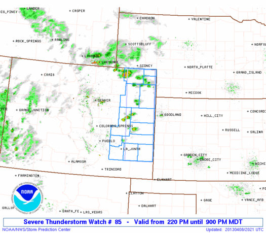
Severe Thunderstorm Watch Box and Radar Image

Radar image of severe thunderstorm near the town of Stratton
Around 6:00 or 7:00 this evening, a strong cold front associated with the storm will move south through the Denver metro area. Gusty winds will switch from southerly to north-northeasterly, and a dramatic fall in temperatures will occur. In fact, after topping 70 degrees at DIA today, the Front Range metro area is going to experience a 50 degree temperature drop over a 12 hour period! The picture below shows thickness values of the air (thicker air = warmer temperatures), which gives a good idea of temperature trends. In most parts of the country, the 5400 meter thickness line is generally the cut-off for the rain/snow line or freezing level, but in the higher elevations of the mountain west around Denver, the 5520 line is used to determine rain/snow line. Regardless, you can see how close together the colder lines are over southern Wyoming (as of recent), indicating a cold surge working its way south toward Colorado.

A sharp dip in the thickness levels over Wyoming indicate the approximate location of the cold front
Upslope rain showers will develop within an hour or two of the frontal passage, and as temperatures plummet, rain will change over to snow between 10 pm and midnight. Snow will be heavy at times overnight, and winds will be gusty as well, creating blizzard conditions for some areas... in fact Blizzard Warnings are in effect from Pueblo to Colorado Springs to Castle Rock. There is still some uncertainty as to where the heaviest snow will fall in the Front Range... the storm track is still trending fairly far to the north, meaning the heaviest accumulations will fall in eastern Wyoming, western Nebraska, and the Dakotas. However, the Front Range metro area should still be in line for good snow accumulations... just not as much as originally thought a day or two ago
The Front Range metro area from Denver to Boulder to Ft. Collins can expect 5-9 inches of snow total, with the highest amounts farther north towards Ft. Collins. Areas from Colorado Springs to Pueblo will only see 2-6 inches, with most of the energy centered farther north, but strong winds will create blizzard conditions for this region. The Front Range foothills should the most snowfall, with 8-16 inches likely for areas at and above 7,000 feet. For the mountains, areas along and west of the Divide will see less snowfall due to an unfavorable wind direction from the east, but plentiful moisture and storm energy could still produce some heavy bands with spotty accumulations. The notable exception will be in the San Juan Range, Sangre de Christo Range, and the eastern sides of the Sawatch and Mosquito Ranges, all of which could see a foot or more of snow. The image below shows abundant moisture at an altitude of about 10,000 feet (700 millibar pressure level) moving into Colorado, as of 4:00 pm local time.

The storm will hang around through Tuesday evening before snowfall tapers off across the Front Range. Unseasonably cold temperatures will be present tomorrow, with daytime temperatures struggling to stay above 20 degrees in Denver... yes you read that right, after a daytime temperature of 70 today, daytime temperatures tomorrow will be about 20 (if not colder). Temperatures on Tuesday night will fall into the single digits, potentially reaching record levels. Skies will slowly clear on Wednesday, but high temperatures will be nearly 30 degrees below average.
Sunday, April 7, 2013
Major spring storm to bring snow and dramatically colder temps to Northeast Colorado

A large spring system is going to bring severe thunderstorms, snow, and near record cold to parts of Colorado on Monday and Tuesday. I'm a little skeptical of some of the huge snow predictions from the National Weather Service, as the storm may track a little too far to the northeast. But since we are still two days out, the track could change... and even a slight shift in the storm track could make a big difference in snowfall amounts. Day-by-day details below...
Rest of Sunday
A few isolated showers and thunderstorms are popping up over the Plains, and isolated rain and snow showers in the mountains, but otherwise, Sunday is turning out to be a warm, quiet, nice day for most areas... the calm before the storm. Another mild day will occur on Monday before dramatic changes occur.
Monday afternoon
As a strong low pressure system approaches from the West, temperatures will still remain mild, with high temperatures across the Front Range metro area and eastern Plains reaching the mid 60's, and high temperatures in the mountains near 9,000 ft. reaching the mid 40's. On Monday afternoon, as the system approaches, the air across the eastern Plains will be warm and unstable, and the approaching cold front will help to spark strong to severe thunderstorms across the region. Far eastern Colorado will be the most likely bet for supercell storms, with even higher chances as you move into Kansas. Lightning, strong winds, and even isolated tornadoes will be possible, especially near the Kansas border. Thunderstorms will be possible in the Denver area as well, but with virtually no severe threat.
The graphic below shows projected values of convective available potential energy (CAPE) for Monday afternoon. Higher convective energy means that moisture can quickly rise from the surface to higher altitudes, due to heating and other forcing mechanisms (in this case, for example, a cold front) thus producing stronger thunderstorms. In laymen's terms, CAPE generally means "thunderstorm potential", with the higher values corresponding to severe thunderstorm potential. Relatively high CAPE values look to extend into far eastern Colorado on Monday. The Storm Prediction Center has extended a "Slight Risk" of severe thunderstorms into this area as well.
Projected CAPE values for Monday afternoon

Storm Prediction Center Outlook for Monday
Heavy snow will begin in the Southern San Juan Mountains on Monday afternoon/evening as well, favoring areas such as Wolf Creek, Purgatory/Durango, and Silverton. Convective snow showers will pop up across the central and northern ranges as well, but due to an unfavorable wind direction from the southwest (and later, the northeast, as the storm turns upslope), most of these areas won't see big snow accumulations.
Monday night
On Monday evening, a strong cold front associated with the storm system will pass through, bringing a rapid drop in temperatures along with an onset of steady precipitation in the Front Range. Heavy snow in the San Juans will spread east toward the Sangre de Christo Range, and will quickly begin in the Front Range after the cold front passes through and winds switch to northeasterly.
Precipitation will initially begin as rain in the Front Range metro area and across the Plains. In the foothills, precipitation will briefly begin as rain, but will quickly change over to snow. In Denver, Boulder, and Ft. Collins... rain should change over to snow between 10 p.m. and midnight, from north to south. Between mid afternoon and midnight, this region will experience a 30 degree temperature drop. On the eastern plains, the changeover to snow will occur later in the night, as temperatures drop from west to east. Snow will continue through the night in the San Juans, but will gradually taper off on Tuesday morning as the storm's energy moves east.
Tuesday
Moderate to heavy snow will continue throughout the day Tuesday for the Front Range, winding down by early evening. The exact track of the storm will determine who receives the heaviest snowfall accumulations. Earlier today, the NWS issued a Winter Storm Warning for most of the Denver/Boulder forecast area, calling for 9-13 inches for the Front Range urban corridor from Denver to Ft. Collins... 8-14 inches for the Front Range foothills and mountains... and 6-11 inches for the eastern Plains.
From looking at the models and data today, I'm a little concerned that the storm may track too far to the north and east for Denver to receive the kind of snowfall totals the NWS and some models are predicting. The latest model runs have trended the storm a little farther to the northeast, focusing the heaviest precipitation over eastern Wyoming, Western Nebraska, and the Dakotas.
Also, from looking at some past storm comparisons, the current system is very similar to a storm that affected the region in early April of 2009. As I remember, the 2009 storm was expected to bring big snowfall totals to Denver, but ended up being a complete bust. Denver received very little snowfall, just barely missing out on the South, while areas farther north such as Ft. Collins received 7-10 inches.
The 2009 storm did track farther east than what models are predicting with the current storm, so Denver isn't going to miss out completely... but it just goes to show how a slight shift in storm track can lead to big snowfall discrepancies, and it is certainly possible that Denver could underperform with this storm if the heaviest precipitation stays to the north. However, a few factors will still favor the Denver metro area to receive significant snowfall... favorable northeasterly winds, very cold temperatures for April (higher snow-to-water ratios), and the upslope effect (rise in elevation "wrings out" more moisture with favorable winds).
As a result, I'm predicting that 6-10 inches of snow will fall in Denver... less than what some are forecasting, but still significant. I'll probably refine this prediction tomorrow based on the storm track (like I said, a slight shift either way can make a big difference). In addition, even though it's April, very cold temperatures will lead to snowpacked roads on Tuesday, in spite of the warm temperatures leading up to the event. This, combined with gusty winds and blowing snow, will make for hazardous driving conditions on Tuesday.
Near record cold will arrive with this system, as high temperatures in Denver on Tuesday will remain in the low 20's throughout the day (similar cold with what we saw in the snowstorm a couple of weeks ago). On Tuesday night, as the system exits to the East, temperatures in Denver will fall to near record levels for April into the upper single digits!
For the mountains and ski areas, most resorts are not in a favorable location to receive big snowfall from a storm like this. Wolf Creek, Silverton, and Purgatory in the Southern San Juans will likely receive big snow totals, along with Monarch, which also does well with this type of upslope set-up. In the Front Range, Eldora should have a nice powder day on Tuesday and Wednesday, but the upslope won't be quite strong enough to produce big snow totals along the Continental Divide at places like Loveland and A-Basin. Areas west of the Divide will be sitting in the snow shadow for this event, so despite what some weather services predict, these areas will not see much snow. Fortunately, that will change later in the week, though.


NWS Snow Probability Forecast for 8 inches or more... notice how the Denver area is right on the southern borderline
Wednesday and Beyond
Active weather is going to continue through the remainder of the week, which is great news as we continue to capitalize on some much-needed moisture this spring. Behind the main system, a series of weather disturbances will move across northern and central Colorado behind a steady, moist northwest flow. Two to three days of persistent snow showers will be likely for the northern and central mountains ranges (especially along and north of I-70), potentially bringing great late season skiing conditions. After Friday, there is uncertainty regarding what the weekend will bring, but the storm track looks to stay active for the near future, so continued snow chances are likely to occur.
In Denver, the post-storm warm-up will be slow, considering its April. Highs will only reach the 30's on Wednesday despite sunny skies, as snowcover will keep high temperatures in check. On Thursday, temperatures will rise into the upper 40's, but an increase in clouds associated with the next weather system will occur, and rain and snow showers will be possible later in the day as a weak disturbance moves through. Temperatures gradually warm through the end of the week into the weekend, but will still remain below average for mid April.
Saturday, April 6, 2013
Major storm to bring snow to Denver overnight Monday... big accumulations possible in foothills

Rest of the weekend... Seasonably warm temperatures in Denver; snow showers and light to moderate accumulations in the mountains Saturday night... good late season skiing conditions. Then, attention shifts to the big spring storm heading our way on Monday...
Strong low pressure system moves across Southern Colorado on Monday. With warm temperatures ahead of the system, thunderstorms will fire up across the Eastern Plains on Monday afternoon, including the Denver metro area, with severe storms possible in far eastern Colorado.
Monday night, precipitation begins across the Front Range as a sharp cold front moves through... 1-2 feet of snow will be possible in the foothills above 7,000 ft. Rain will change to snow overnight in the Denver area... with colder air filtering in along with a lack of sun during the nighttime hours... several inches of snow will likely fall in the city. Temperatures on Tuesday will be 30 degrees colder than on Monday.
Behind the main system... steady, moist northwest flow could bring a 2-3 day cycle of snow for the northern and central mountains, which would create awesome late season skiing conditions.
There is still some disagreement with models on the exact storm track, so a slight shift in the storm track could change things up a bit. Stay tuned...
Friday, April 5, 2013
Mostly cloudy, temps in the 60's for Denver this weekend; snow showers for the mountains
The high pressure ridge responsible for the warm weather the past couple of days is flattening as a couple of weak disturbances move into the state. Convective rain and snow showers are developing over the northern mountains, with snow showers a good bet for the higher elevations in the northern and central mountains overnight. Spotty accumulations of a few inches will be possible depending on where the heaviest showers develop. Drier weather returns on Saturday, but skies will remain mostly cloudy for most of the state. Temperatures in Denver will be a touch cooler, with highs in the mid 60's.
Tomorrow afternoon and evening, there will be just enough moisture and instability for a few showers and thunderstorms to develop over northeastern Colorado, while a weak disturbance moving through will produce snow for most of the mountain areas overnight, with mostly light accumulations expected. Dry conditions should return once again on Sunday, with temperatures reaching the 60's once again for the Front Range metro area.
The big story, however, is a significant low pressure system expected to reach Colorado early next week, perhaps bringing big snow to the Front Range foothills. The exact track of the storm has yet to be determined, since it is still four days away, but if the low pressure center sets up in southeastern Colorado, a major precipitation event should occur. There will be plenty of moisture available with this system, and much colder air is expected to filter down from the North, so the ingredients will be there as long as a favorable storm track develops.
The most likely areas to receive heavy snowfall are in the foothills west of Denver (7,000 ft. and above), whereas Denver and the Front Range cities will be on the borderline. Temperatures ahead of the system are going to be warm which, combined with the high April sun angle, will likely limit snow accumulations for Denver. However, significantly colder air will be filtering in, so falling temperatures on Tuesday will likely lead to a changeover to snow at some point (after starting out as all rain or a rain/snow mix) but the exact temperatures as well as how late the storm lasts will be the determining factors. Should the storm persist into Tuesday night, when daytime heating and sunlight diminish, then significant snow accumulations for Denver would not be out of the question... however, the heaviest precipitation may already be over by then.
It wouldn't surprise me if there is a sharp cut-off line between heavy snow accumulations and light accumulations, even within the metro area itself (for example, higher elevations on the western and southern sides of the metro area, such as Golden, may could see noticeably more snowfall due to slightly colder temperatures and lesser effects from the urban heat island) It will certainly be an interesting system to follow in the coming days. As always with storms being forecasted several days in advance, changes in the storm track will likely occur, leading to exact changes in the forecast as the event nears. Snowfall accumulations can't be reliably predicted this far in advance either. Keep in mind that models will get a better handle on the storm once the system makes landfall off of the Pacific and more data is available (much less weather data is available over the oceans than on land).
Thursday, April 4, 2013
Nice weather to continue through Friday; big changes on the way early next week
Most of Colorado is experiencing beautiful weather today, with temperatures currently in the upper 60's in the Denver metro area under sunny skies. The ridge of high pressure responsible for the milder weather will begin to break down tomorrow, leading to stronger westerly winds, especially for the Front Range. Sunny skies and warm temperatures will continue, though, with highs expected to be even warmer than today, topping out in the low 70's for Denver.
In the mountains, high temperatures should reach 50 degrees as high as 9,000 feet, with afternoon heating along with some instability in the atmosphere creating convective clouds and isolated rain/snow showers and thunderstorms.
Unsettled weather returns this weekend
Warm and sunny weather on Friday will gradually give way to clouds and precipitation chances this weekend as a couple of weak disturbances move through. Snow showers will be possible for the northern and central mountains Friday night, but accumulations will likely be random and on the lighter side. Clouds increase statewide on Saturday ahead of the next disturbance, with high temperatures about 5-10 degrees cooler than Friday's highs. The mountains will see a round of snow Saturday night into Sunday morning, with light to moderate accumulations possible, favoring the northern and central ranges. Snow showers will be possible throughout the day Sunday as well.
As the disturbance moves through on Saturday night, rain showers and perhaps a few rumbles of thunder will be possible for Denver and northeast Colorado, but precipitation amounts should be on the lighter side. Highs in Denver on Saturday and Sunday are expected to reach the 60's, but skies will stay mostly cloudy.
Major spring storm possible for the Front Range early next week
By early next week, a strong low pressure system will move inland from the Pacific toward the Four Corners region, setting up what could potentially be a major spring snowstorm for the Front Range, likely favoring the foothills and areas east of the Continental Divide the most, as well as the Southern San Juans initially. Much colder air is expected to arrive with this system as well, so accumulating snowfall in the Denver metro area will be a possibility as well. Borderline temperatures and a high sun angle are typically more of an issue for April snowfall accumulations in Denver, so this will likely be a tricky forecast for the Mile High City until a day or two before the event. Confidence in significant snowfall for the foothills and mountains west of Denver is much higher, though.
Nevertheless, this storm is still five days away, and variations in the exact storm track from what the models are showing are almost inevitable. Additionally, there is still uncertainty regarding how long the low pressure system will hang out over Colorado. A one-day storm versus a two-day storm will make a huge difference in snowfall and precipitation amounts.
Tuesday, April 2, 2013
Rain and snow to give way to gradually clearing skies

Heavy snow forced I-70 to close in Summit County for a few hours Tuesday afternoon
Cold rain continues to fall in Denver overnight Tuesday, while heavy snow showers wind down in the mountains. Easterly winds along with low level moisture kept temperatures from rising much in the metro area, as highs only reached the upper 30's to low 40's across the urban corridor. Off and on rain showers began around noon on Tuesday, with a more steady rain overtaking the region Tuesday evening with temperatures hovering in the 30's. The high amount of moisture near the surface is causing temperatures to remain steady, so if a changeover to snow in Denver occurs, it will be late into the night. Nevertheless, the city could very well wake up to a dusting of wet snow Wednesday morning, while wet snow accumulations on grassy surfaces are more likely from Golden to Boulder, and higher elevations farther west in the foothills.
Heavy, convective snow showers developed in the mountains today as a low pressure system moved from Utah into Colorado. The snow showers popped up in a summer thunderstorm-like fashion due to the amount of instability (more common in the spring than winter due to more heating), with the heaviest snow concentrating around the Summit County, the Gore Range, Independence Pass, and the Front Range mountains (Indian Peaks and RMNP especially) where many locations received 6 inches or more. The heavy snow caused I-70 to close this afternoon between Frisco and Copper Mountain, as seen in the picture above. Ski conditions should be quite good for Summit County, and possibly others on Wednesday.
Drier weather returns on Wednesday, but stubborn clouds to hang around
Precipitation in the Front Range metro area should be over by daybreak on Wednesday, but morning clouds and fog will make for a damp and chilly morning with temperatures starting out near freezing in the city. Overcast skies will slowly dissipate throughout the day as the low pressure system moves east of Colorado, with high temperatures in the metro area reaching the upper 50's (upper 40's to low 50's for the foothills).
Snow will also come to an end in the mountains overnight Tuesday, but mostly cloudy skies will hang around for most of the day, as a ridge of high pressure from the west slowly creeps toward Colorado. Highs in the mountains will range from the low 50's around Steamboat, to the upper 30's/low 40's near 9,000 feet, to the 20's above 11,000 feet.
Warmer temperatures and sunny skies on Thursday and Friday; more unsettled weather arrives this weekend
A ridge of high pressure will move in on Thursday, bringing nice spring-like temperatures to the state with highs in Denver likely topping 70 on Friday. Spring snow conditions will return to the mountains as well. The spring roller coaster will continue, however, as the ridge flattens on Friday, and moisture returns to the state on Saturday. The weekend weather pattern looks fairly unorganized for now, but expect the mountains to see some snow on Saturday and Sunday. Denver and northeast Colorado should stay mostly dry on Saturday, but could see a round of upslope precipitation as a system moves through on Sunday. Looking ahead to early next week, a fairly active weather pattern could take shape, bringing more precipitation chances to the state. As for temperatures, a cooling trend begins on Saturday in Denver, continuing into Sunday and Monday.
Subscribe to:
Posts (Atom)