Saturday, March 23, 2013

Moderate to heavy snow continues for Denver, with storm totals of up to a foot or more possible


The Front Range and Eastern Plains are experiencing quite a late season storm today, with heavy snow and temperatures of about 30 degrees below average.  Heavy snow began in Denver shortly after sundown last night and continues through Saturday, with locations in the metro area reporting 7-11" as of 10:30 a.m., with a foot or more possible by the time the storm winds down later this afternoon/evening.  As of noon on Saturday, the temperature in Denver is still only 15 degrees, so this is a very cold storm for late March.  Even heavier snow is occurring out on the northeastern Plains, where areas could see more than a foot, while areas north of Boulder to Ft. Collins will see less snow.

Travel conditions are nasty today due to the blowing snow and snowpacked/icy roads due to the cold temperatures.  Parts of I-70 east of Denver are closed, and a 6-mile stretch west of Denver between C-470 and Genesee is also closed.

In the mountains, areas west of the Divide will not see much snow from this storm, but later tonight and throughout the day tomorrow, wrap-around snow from the storm behind a northwesterly flow will develop, bringing accumulating snow to the northern mountains.


A second, lighter snow event to reach Denver Sunday night

Tomorrow evening, another weaker system will pass through bringing a secondary cold front, and another round of accumulating snow to the Denver area.  Accumulations will be lighter this time, though, with a couple of inches likely.  Nevertheless, winter is full force this weekend with unseasonably cold temperatures.  Highs today will struggle to top 20 in Denver, with lows dropping into the single digits tonight.  On Sunday and Monday, highs will likely remain in the 20's in Denver as well.  For some perspective, average highs in Denver for this time of year are in the upper 50's.


Dry weather returns Tuesday

The cold air will finally begin to subside and warmer temperatures will return starting on Tuesday, with sunny skies and progressively warmer temperatures throughout the week.  By the end of the week, Denver should see highs reaching the 50's again.  Unsettled weather could return next weekend, but this is 7+ days out so confidence is low.

Friday, March 22, 2013

Heavy snow dumps up to a foot of snow in the mountains on Thursday; Denver in line for 3-7" of snow Friday night into Saturday

I only have time for a quick update, as I have been slammed at school for the past couple of days, and the ski slopes are calling my name this morning.  Heavy snow moved through the mountains yesterday, dropping about a foot for some areas, including Aspen, Vail, Breck, and Copper, with Loveland and A-Basin picking up close to 10 inches as well.  Skies are clearing this morning, but a sharp cold front associated with the next system will arrive tonight, bringing a band of heavy snow to the northern mountains initially... then, winds will switch to the northeast, and upslope snow will occur, bringing snow to the eastern foothills, Denver metro area, and eastern plains.

The models have not been getting a good handle on this storm for Denver, but for now it looks like there will be abundant moisture and favorable winds.  On the flip side, the system will be fast moving, which could limit accumulations.  Still, expect decent accumulations with periods of heavy snow.  Denver should pick up between 3 and 7 inches, while areas on the far eastern plains could end up picking more.  Areas in the foothills could receive up to 10 inches, as the higher elevation will help to produce more moisture, which in turn will produce more snowfall.

Sharply colder temperatures arrive with this system... highs in Denver tomorrow will stay in the 20's, with lows Saturday night possibly dropping into the single digits.  In fact, cold air will stay through the weekend, with highs on Sunday and Monday struggling to reach the freezing mark as well.  Wrap-around snow showers will develop Saturday evening in the northern mountains behind the system.  There will be a break on Sunday, then yet another system moves in Sunday night, bringing snow to the northern mountains, and possibly another round of upslope snow to the Denver metro area as well.  Snow showers continue in the mountains on Monday, then drier conditions finally move in by Tuesday.  March is living up to its reputation for stormy weather in Colorado this year, which given the drought conditions and low snowpack across the state, is a very good thing.

Tuesday, March 19, 2013

Cold and snowy weather pattern on the way for Colorado

Possible storm tracks for Colorado late this week into early next week


Brisk winds and seasonably chilly temperatures continued across the state on Tuesday, with a 56 mph wind gust recorded in Boulder and a 63 mph wind gust recorded on Berthoud Pass.  Highs in the Front Range cities ranged from the upper 40's to low 50's, which is slightly below average for this time of year, while highs in the mountains ranged from the teens (above 11,000 ft.) to the 30's (valleys).  An active weather pattern is on the way, with the first storm reaching the mountains Wednesday night, and a stretch of unseasonably cold temperatures on tap statewide for this weekend into next week.


Wednesday - the calm before the first storm

Temperatures will warm up 5-10 degrees from the day before across the Front Range on Wednesday, but clouds will be on the increase as a low pressure system approaches Colorado from the west.  Highs will reach the upper 50's across the Front Range cities and eastern plains, and the upper 40's to low 50's for the foothills.  Winds will be much calmer across most of the Denver metro area, although breezy conditions are still expected across the eastern plains as well as the foothills just east of the Indian Peaks, and to a lesser extent, the Colorado Springs area.


First storm arrives Wednesday night, favoring the Central Mountains

The first in a series of storms over a several day period will reach Colorado late Wednesday afternoon/evening behind WSW winds, bringing moderate to significant snow accumulations to much of the mountain regions.  The Elk Range, Grand Mesa, Beaver Creek/Vail, and Northern San Juan Range will be favored the most, but good snowfall will be possible across most mountain ranges through Thursday afternoon before the storm exits.

On Thursday evening, a cold front associated with the storm system will pass through northeastern Colorado, bringing a round of precipitation to the northeastern Plains, and possibly the Denver metro area as well.  Precipitation will mainly be in the form of rain, at least initially, but a switchover to wet snow will be possible into the nighttime hours.


Much colder temperatures to arrive on Saturday, along with snow for the Front Range

After the first storm exits, a stronger low pressure system will develop over Colorado beginning on Friday, bringing in a very cold (for late March) airmass from the north, along with ample moisture from the east.  The result is that snow will likely develop east of the Continental Divide, including Denver and Boulder.  Models are beginning to show some consistency with this storm, but it is still several days away so it is too early to speculate on how much of an impact it will have, who will get the most snow, and what kind of snow accumulation amounts to expect.


Moist, northwest flow pattern expected to develop later in the weekend for the mountains

Following the Front Range storm on Saturday, several days of orographically-enhanced (i.e. terrain-induced) snow behind northwest winds will be possible for the northern and central mountains, which would be excellent news for ski resorts.  This forecast is even farther out in advance than Saturday's storm, though, so it is only a possibility at this point, but if the forecasted events in the coming days verify, then the likelihood of a northwesterly flow pattern developing would be fairly high based on past experiences.


Monday, March 18, 2013

Mostly clear on Tuesday, unsettled weather to arrive later this week

Clear skies, but brisk winds were prevalent across the Front Range cities on Monday, while snow showers continued in the mountains under a northwest flow, with many locations picking up an additional few inches.  Highs along the urban corridor reached the mid 40's to low 50's, while the mountains experienced much colder temperatures with highs in the 20's above 9,000 ft. and teens near and above treeline.  Strong winds raked the higher elevations as well, with Berthoud Pass recording a 52 mph gust and Storm Peak, at the top of Steamboat Ski Resort, recording an astonishing 81 mph wind gust!


Tuesday

A weak ridge of high pressure will build into Colorado on Tuesday, with calmer but continued breezy conditions expected for the Front Range, especially in and near the foothills, as well as on the northeastern plains.  Skies will remain mostly clear with high temperatures reaching the low to mid 50's for the urban corridor, and the mid 40's for the foothills.

Clear skies and slightly warmer temperatures will return to the mountains on Tuesday, although brisk winds will continue for the higher elevations.  High temperatures will reach the 30's in the valleys above 8,000 ft. and the low 20's near and above treeline, with 40 mph gusts possible along the Continental Divide.


Next storm arrives Wednesday night, lasting into Thursday afternoon, bringing snow mainly to the mountains

The high pressure ridge will begin to break down during the day Wednesday, with slightly milder temperatures but increasing clouds for most of the state ahead of an approaching low pressure system.  By Wednesday night, snow will arrive in the mountains and should last through the day Thursday with moderate accumulations possible, favoring the central mountains the most.  Winds will start out from the WSW before gradually switching toward the WNW during the day Thursday.  

By Thursday afternoon or evening, a cold front associated with the system will move through northeast Colorado, and a band of precipitation will likely develop over the northeastern plains, possibly affecting the Denver metro area as well.  Precipitation would likely start as rain, but could mix with or change to snow later on.  At this point, confidence is low on the type, intensity, and duration of precipitation for northeast Colorado and Denver, but it is unlikely to be a major event.


Colder, stormy pattern ahead for this weekend

After the Thursday storm, there will be a brief lull in the action before more weather arrives this weekend.  Confidence is low on the details this far in advance, especially since there have been some discrepancies in the last few model runs, but a potentially significant storm system could affect the state from Friday through Monday, bringing good snow to the mountains, and perhaps even an upslope snowstorm to Denver and the Front Range late in the weekend.  It will be something to keep an eye on throughout the week.  At the very least, temperatures will likely be well below average throughout the weekend into early next week. 


Sunday, March 17, 2013

Windy and cooler on Monday

A cold front moved through Colorado on Sunday afternoon, bringing strong winds to much of the state and snow showers to the mountains.  Winds in the Front Range cities gusted to over 40 mph, while both Loveland and Berthoud Passes on the Continental Divide recorded wind gusts in the 50's.  The northern and central mountains saw a round of snow this afternoon, with SNOTEL stations indicating just a few inches for most areas, although Vail picked up about 6 inches.  Much colder temperatures have arrived in the mountains, with overnight lows Sunday night expected to drop into the single digits for the higher elevations.


Monday

Clear skies, but gusty winds and cooler temperatures behind Sunday's cold front will be the main story for Denver and the Front Range on Monday.  High temperatures in the Front Range urban corridor and Eastern Plains will reach the upper 40's (5-8 degrees below average), with wind gusts in the 30-40 mph range.  In the foothills (7,000-9,000 ft.), highs will only top out in the upper 30's, with 35-40 mph wind gusts also expected.

Mostly cloudy skies will continue for the Northern and Central mountains (Aspen and areas north) on Monday, with snow showers possible for the higher elevations.  Cooler temperatures will be in store, with highs in the 30's for areas below 9,000 ft., highs in the 20's for areas 9,000 ft. and above, and teens for areas near and above treeline.  Wind gusts will range from 25 mph in areas below 9,000 ft. to 50+ mph for areas near and above treeline.

In the Southern mountains, temperatures will also be cooler, but skies will be mostly clear south of the Elk Range with relatively lighter winds than areas farther north.  Highs will range from the mid 30's near 9,000 ft. to the mid 20's near and above treeline, with wind speeds between 15 and 30 mph expected, with locally higher gusts near and above treeline.


Warmer on Tuesday and Wednesday, with increasing clouds on Wednesday

A weak ridge of high pressure will move into Colorado on Tuesday, raising high temperatures by about 10 degrees for most areas.  Relatively mild temperatures will continue on Wednesday (near 60 in Denver), but clouds will be on the increase ahead of the next system expected to reach Colorado on Wednesday night.


Series of storms to affect the mountains from Wednesday night through the weekend

Skiers and snowboarders should take notice, as a potentially significant period of stormy weather is expected for the mountains for late this week, possibly lasting several days.  The first storm should arrive from the West overnight Wednesday into Thursday, with more rounds of snowfall to follow.  Most mountain areas could do well with snowfall, with the potential for a couple of days of moist northwest flow for the northern/central mountains possible into the weekend.  Denver should mostly stay dry on Wednesday night, but a round of snow will be possible overnight Thursday as a second wave passes through, but keep in mind this is only a "possibility" this far out.  In general, the storm pattern that models are indicating will favor the mountains west of the Continental Divide. 


Friday, March 15, 2013

Unsettled weather arrives for the weekend

Spring weather continues in Colorado on Friday, with temperatures in the Front Range cities currently in the 70's, with Denver threatening to reach its record high temperature for the day of 75 degrees.  Mild temperatures continue in the mountain regions as well, with 50's for areas as high as 9,000 feet (yesterday, the high in Aspen was 60!).  Changes are one the way, though, as a weak system moves through tonight, dropping temperatures and bringing precipitation chances on Saturday.  Then, a second, colder system arrives on Sunday afternoon.


Denver, Front Range, and Eastern Plains

Well above average temperatures continue for the Front Range and Eastern Plains today, before a cold front arrives overnight, bringing much cooler temperatures and rain showers for Saturday (which is not what St. Patrick's party-goers in Denver will want to hear).  The first round of showers should move through on Saturday morning, with a second round of showers (more convective, i.e. "pop-up" type) likely to pass through later in the afternoon, with even some thunderstorms possible.  Rain chances will be greater farther east on the plains, where a steady band of precipitation could set up.  Temperatures start out in the 30's with highs topping out around 50 under overcast skies, while slightly cooler temperatures will be found in the foothills, with snow showers possible along with rain showers.  Snow showers will develop along the Continental Divide as well, with spotty accumulations expected depending on where the heaviest showers develop.  Temperatures warm up on Sunday as the region will be in between systems, but a stronger cold front later in the day will bring colder temperatures and higher winds for Sunday night, although little to no snow is expected for the Front Range cities.  The Front Range mountains will see accumulating snowfall as the cold front passes through, though.


Northern/Central Mountains

A cold front associated with a weak system will move through overnight, producing snow showers over much of the region on Saturday.  Temperatures will still be relatively warm, even behind the front, with a marginal overnight freeze expected in the valleys, so snow levels will start out high with rain possible as high as 9,000 feet.  The snow that does fall will be wet and convective in nature ("scattered heavy showers" variety), so accumulations will be spotty across the region, but some areas could pick up decent totals.  A more organized system will move through on Sunday afternoon and evening, with much colder temperatures and another round of snowfall expected, likely producing moderate snow totals for the ski areas by Monday morning.


Southern/Western Mountains

Snow showers will develop across the western and southern mountain ranges as well on Saturday morning as the cold front moves through, bringing mostly light and spotty accumulations favoring the Elks and Northern San Juans, with moderate accumulations possible depending on where the heaviest showers occur.  The system moving through on Sunday will bring a round of accumulating snowfall as well, with the Elks and Northern San Juans once again likely to be favored, as the overall system is going to favor Northern Colorado in general.  Areas from Telluride to Silverton to Aspen could see moderate snow totals by Monday morning, though.  Temperatures also won't fall as dramatically behind the system on Monday compared to the northern part of the state, but they will still be much cooler than the currently balmy temperatures affecting the region.  The Southern San Juans (including Wolf Creek) and Sangre de Christos will likely only see a few snow showers this weekend, with little in the way of accumulations expected.


Medium/Long Range

Much colder temperatures arrive for most of Colorado on Monday (especially in the northern mountains) behind the system moving through Sunday night.  However, a ridge of high pressure moves into Colorado for the early part of the week, bringing another round of mild temperatures by midweek.  Then, the spring roller coaster continues with models hinting at a potentially significant multi-day storm system for the mountains late next week lasting into next weekend.


Wednesday, March 13, 2013

Spring-like warmth continues for all of Colorado

Significantly warmer temperatures arrived in northeastern Colorado on Wednesday, with highs topping 60 in most of the Front Range cities, which was 20-30 degrees warmer than the day before.  Sunny skies and above average temperatures continued in the mountains, with highs in the valley towns ranging from the mid 40's to low 50's.  Spring weather continues statewide through the end of the week, with more unsettled (but still fairly mild) weather on tap for the weekend.


Denver, Front Range, and Eastern Plains

The warm-up for northeastern Colorado continues on Thursday, with highs along the I-25 corridor pushing 70 degrees (mid 60's near the base of the foothills for areas such as Boulder and Golden) under sunny skies.  Low temperatures Thursday night will be mild once again, ranging from the mid 30's (eastern plains) to low 40's (Boulder/Golden).  Mild temperatures will reach the Front Range foothills and mountains as well, with highs near 8,000 ft. ranging from the mid 50's to low 60's, and highs along the Continental Divide near treeline reaching the mid 30's with increasing winds in the afternoon.  Even warmer temperatures are in store for the region on Friday, with relatively cooler air arriving on Saturday.


Mountains

Spring skiing will be the rule once again, with unseasonably warm air pushing high temperatures into the upper 40's to mid 50's for many of the ski resort towns.  For the higher elevations, highs will reach the mid 30's (north) to low 40's (south) with increasing winds for the afternoon hours (more noticeable farther east and near the Continental Divide).  Warm temperatures persist into Friday, before clouds and some snow showers arrive on Saturday.


Medium to Long Range

The ridge of high pressure affecting Colorado will begin to break down later Friday, and a weak system will affect the area on Saturday, bringing some clouds, slightly cooler temperatures and a chance of snow showers for the mountains, and even some rain showers possible for Denver metro and the eastern plains.  The system is looking weaker now than it did a day ago in terms of mountain snowfall.  On Sunday night, a more substantial storm could affect the mountains, but there is a lot of uncertainty for now, as the American GFS model keeps the storm north of Colorado, while the European model (which is often more accurate) shows a more favorable storm track for snow in the northern and central mountains.


Tuesday, March 12, 2013

Clear weather to last through Friday

The latest weather system exited northeast Colorado on Tuesday, leaving behind a few inches of snow and below average temperatures for the Front Range urban corridor and as much as eight inches of snow for the Front Range mountains.  A ridge of high pressure is now moving into Colorado, bringing sunny skies and progressively warmer temperatures to the state through the end of the week.


Denver, Front Range, and Eastern Plains

Cloudy skies hovered over northeastern Colorado for the early part of Tuesday, following an overnight snow event, before the sun came out in the afternoon, quickly melting most of the snow in Denver.  Below average temperatures prevailed, though, with highs across the metro area ranging from the low 30's near the foothills to 40 at DIA.  Clear skies return to the region on Wednesday, bringing warmer, but still seasonably cool temperatures, with highs reaching the low 50's for most of the metro area.  Farther south, warmer air will arrive on Wednesday, with highs reaching the lower 60's in Colorado Springs.  Warmer air moving in from the west will keep low temperatures on Wednesday night surprisingly mild (mid to upper 30's), with highs on Thursday warming into the 60's for most of the region.  Noticeably milder temperatures will arrive in the Front Range mountains as well, although winds along the Continental Divide will remain brisk.


Northern/Central Mountains

Warmer air has already reached areas west of the Continental Divide, with highs topping 40 for many of the valley areas on Tuesday, making quick work of the fresh snow that fell on Monday.  Sunny skies will return on Wednesday as well with valley highs reaching the upper 30's in Summit County (9,000 ft.) to upper 40's in Steamboat (6,600 ft.), and highs near treeline reaching the upper 20's with brisk winds farther east toward the Divide.


Southern/Western Mountains

The most recent storm system did not affect the southern mountains, which have already experienced mild temperatures associated with the high pressure ridge moving into Colorado.  High temperatures in Aspen and Telluride were warmer on Tuesday than in all of the Front Range cities.  On Wednesday, sunny skies and mild temperatures will create spring skiing conditions once again, with valley temperatures reaching the upper 40's, and higher elevations reaching the 30's.


Medium/Long Range

Spring-like weather will last through the end of the week, with highs on Friday likely to top 70 in Denver.  The high pressure ridge begins to break down on Friday, however, as the next storm system is expected to reach Colorado by Saturday night, bringing snow to the mountains.

Monday, March 11, 2013

Surprise snow comes to an end Tuesday morning, spring warmth to arrive on Wednesday

Radar image showing light snow over Northern Colorado on Monday night


A weak system moved through northern Colorado this afternoon, and light snow has been falling across the Front Range metro area all evening.  Earlier in the day, it looked like the metro region would stay mostly dry with the bulk of the precipitation farther to the northeast, but the cold front dropped farther south than the models indicated, and a surprise snowfall spread into the metro area, with light accumulations occurring.  The heaviest of the snow is falling in Ft. Collins and Greeley, with a few inches possible there by daybreak, with lighter accumulations farther south into Denver.  It seems like a few times every winter, small snowstorms like this catch Front Range forecasters by surprise.  This is something I actually want to research when I have more time this summer.


Denver, Front Range, and Eastern Plains

Most of northeastern Colorado will wake up to overcast skies and a little bit of snow on the ground Tuesday morning, but skies will gradually begin to clear out during the day, with temperatures rising into the mid to upper 40's across the urban corridor.  Northwest winds will be predominant, drying out the air east of the mountains, but keeping clouds and snow showers present over the high peaks near the Continental Divide through the early part of the day.  Big changes are coming on Wednesday, though, as a ridge of high pressure moves into Colorado, bringing sunny skies and the warmest temperatures of the year thus far, with highs reaching the 60's in Denver on Wednesday, and rising to 70 by Friday.


Northern/Central Mountains

A moist, northwest flow brought light snow to the northern mountains on Monday, from Steamboat to Vail/Summit to the northern Front Range.  Snow showers should continue through Tuesday morning for most areas, with light totals expected... just enough to freshen up the slopes.  Relatively higher snow amounts are expected in Steamboat and the Park Range, as they usually benefit the most from northwest flow type systems.  Most of the snow will end by Tuesday afternoon, as high temperatures reach the 30's for most of the valley towns (20's above 11,000 feet).  Clearing skies and substantially milder temperatures are in store for Wednesday through the end of the week.


Southern/Western Mountains

The mountain regions south of I-70 have remained dry for the most part, as the system moving through Colorado remained well to the north.  Mostly sunny skies and warmer temperatures will be predominant throughout the area on Tuesday, with the March "heat wave" expected to arrive on Wednesday, bringing sunny, spring skiing conditions to the region.


Medium to Long Range

A ridge of high pressure moving into Colorado on Wednesday is going to bring spring-like weather for the next four days, with temperatures possibly topping 70 for the first time this year in Denver on Friday.  Warm temperatures are going to affect the mountains, too, with valley temperatures likely reaching 50 by the end of the week.  Spring skiing will be in full force heading into the weekend.  However, the "heat wave" is not going to last as long as it appeared it would a few days ago.  It now looks like winter weather will return to Colorado by Sunday, with more storms possible the following week (looking very long range). 


What happened to Saturday's snow storm in Denver?

Snow falls at Wash Park in Denver on Sat, March 9


It's no secret to those in the Denver area that the weekend snow storm underperformed, with Saturday's 8-14" forecast by the National Weather Service turning into a general 4-6" for most of Denver.  While the storm wasn't exactly a bust (except for Ft. Collins, which basically saw nothing), with moderate (and at times, heavy) snow falling for most of the day, it certainly wasn't the big storm that many were expecting.

So what happened?  Borderline freezing temperatures, a warm ground, and the high March sun angle are mostly to blame.  Temperatures were hovering around 32-33 degrees when the storm began on Saturday morning, and held steady at about 30 for the remainder of the day.  So while, yes, 30 degrees is obviously cold enough for snow to accumulate, it was not cold enough to overcome the already warm ground combined with higher March sun angle, since all of the snow fell during the daytime hours.  As a result, much of the snow that fell melted and compacted, leading to slower accumulation rates... this made the difference between receiving 5 inches instead of a foot.  

Also, the storm moved out a little quicker than expected, with snowfall ending 2-3 hours earlier than forecasted.  This probably explains why some areas in the foothills received less snow than forecast, although some of these areas still ended up with a foot or more.  There is always a lot to be learned from these storms, so that we can get the forecast right for the next one.  At the very least, the Front Range did receive some much-needed moisture from this storm, although we could definitely use a few more storms this spring.

As for the weather today and this week, warmer temperatures are on the way, with a serious taste of spring arriving by midweek.  Highs in Denver will reach the 50's today, but clouds will move in to area as a weak system brushes Northern Colorado later today, bringing light snow to the northern mountains this evening.  The northeastern Plains may also receive some light snow tonight, but the precipitation will likely stay east of Denver.  After a relatively cool day (for mid March) on Tuesday behind the system, warm and sunny weather arrives on Wednesday lasting through the weekend.  It's going to be our first stretch of prolonged spring-like weather this year, with highs reaching the 60's in Denver each day, perhaps even hitting 70 by Thursday or Friday! 

Saturday, March 9, 2013

Powerful winter storm dumping heavy snow over much of Colorado

Radar image at 11:00 am MST shows heavy snow over much of northeast Colorado (mountain precipitation generally doesn't show up well on radar, since the mountains alter the radar signals)


A big winter storm is affecting most of Colorado today, with heavy, wet snow falling in Denver and the Front Range metro area this morning.  Additionally, heavier snow than expected is falling west of the Continental Divide in Summit County and Vail as a result of some unique wind patterns associated with this system.  The Southern San Juan Range has seen the most snow so far, with Wolf Creek reporting 16" as of 6 a.m. this morning.  Snow began in Denver around 6:00 a.m. and will continue through the late evening, with blizzard conditions expected east of the city.


Denver, Front Range, and Eastern Plains

Steady snow began around sunrise in Denver this morning, with temperatures starting out near to even a little above freezing in much of the city.  Soon after the snow began, temperatures fell below freezing, and will continue to slowly fall into the 20's throughout the day.  The moisture content is high, so the snow that has fallen thus far is of the heavy and wet variety.  The forecast of 8-12 inches for the metro area is still on track, with southern and western areas seeing the highest totals.  As of 11 a.m., NCAR's Marshall Field Site just outside of Boulder is already reporting 4.5 inches.

The heaviest snow will fall in the Front Range mountains and foothills, with 1-2 feet possible at elevations above 7,000 feet up to the Continental Divide.  Areas along the divide such as Loveland and Berthoud Pass are experiencing heavy snowfall, and just on the western side of the Divide, Winter Park is in fact also getting heavy snow today.  Remote sensor stations are already indicating up to half a foot for areas from Berthoud Pass to the Indian Peaks to Rocky Mountain National Park.

On the eastern Plains, heavy snow and high winds are creating blizzard-like conditions.  Blizzard warnings remain in effect for all of northeastern Colorado, with nasty travel conditions expected on I-70 and I-76 east of Denver.  

Snow will come to an end across the region tonight, with overnight temperatures falling into the teens under clearing skies.  Tomorrow, the sun returns to the entire area, with highs in Denver reaching the upper 30's.


Northern/Central Mountains

Areas west of the Continental Divide from Vail to Summit County to the Gore Range are getting in on the action after all, with a complex storm circulation pattern creating favorable wind directions for these areas.  More often than not, Vail and Summit County do not simultaneously receive heavy snow at the same time as Denver, but every storm is different, and today is an exception (so far) with good snow falling for these areas, much to the delight of skiers and snowboarders.  Vail, Beaver Creek, Copper Mountain, Breckenridge, Keystone, and A-Basin were already reporting 3-5" on their early morning snow reports, and surface observations and web cam images have indicated that snow has continued for these areas throughout the morning.  There have been some heavy snow reports from Steamboat as well, although for a change, this area actually looks less favorable than all other areas farther south.


Southern/Western Mountains

Heavy snow arrived in the San Juan Mountains yesterday, favoring the southern part of the range, and will continue into this afternoon before most of the moisture exits to the east.  Early morning snow reports including 16" at Wolf Creek, 9" at Purgatory/Durango, and 8" at Silverton.  Telluride had not received any new snow as of this morning, however, since they are not favored by southwesterly winds.  The Grand Mesa and Elk Range (Aspen/Crested Butte) also did not experience the heavy snow that the San Juans experienced overnight, but radar images and surface observations out of Grand Junction have been indicating moderate snow over these areas throughout the morning.  Farther east, heavy snow will fall in the Sangre de Christo Range today, as this area does will with easterly upslope winds.


Friday, March 8, 2013

Major winter storm to dump up to a foot of snow in Denver in Saturday

Water vapor satellite image as of 3:15 pm MST Friday


A powerful storm system is currently moving into Colorado from the southwest as of Friday afternoon, bringing heavy snow to the San Juan mountains.  The storm will track toward the east overnight Friday, with easterly winds developing early Saturday morning, bringing heavy snow to Denver and the Front Range through Saturday evening.  Skies clear out on Sunday, with sunshine returning to the whole state.  


Front Range and Eastern Plains

Cloud cover has kept temperatures cooler than forecast on Friday, with temperatures holding in the low to mid 40's in the Denver metro area.  Scattered rain and snow showers will be possible late tonight in the metro area as moisture moves into the region ahead of the main system, with an outside chance of thunder occurring with these initial showers.  Temperatures fall to around freezing in the Denver area during the early morning hours with the main precipitation event beginning just before daybreak as all-snow behind northeasterly (upslope) winds.  Moderate to heavy snow will fall throughout the day Saturday along the urban corridor from Ft. Collins to Denver to the Palmer Divide.  

Heavy snowfall will make for difficult driving conditions throughout the day, especially as temperatures slowly fall into the 20's throughout the day and moderate winds lead to blowing snow.  Denver, Boulder, and Ft. Collins should expect a general 8-12" with locally higher amounts possible.  The snow will fall at even heavier rates at higher elevations in the foothills and along the Palmer Divide, due to orographic effects (increase in elevation generates more moisture).  Expect 12-20" of snow to fall in the foothills all the way up to the Continental Divide.

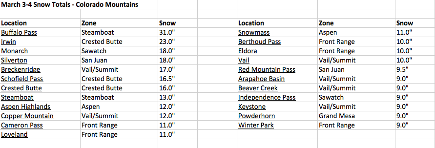
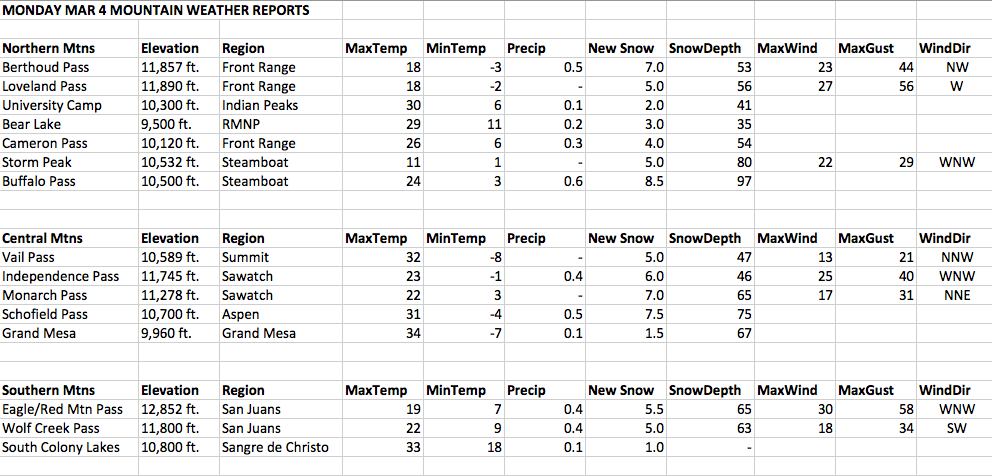
The Divide will act as a sharp barrier, with significantly less snow falling west of the Continental Divide (easterly winds are not favorable for areas west of the Divide).  For skiers, Loveland and Berthoud Pass will still see good snowfall since they are located right on the Divide, but Eldora may see the highest snowfall totals of all ski areas in the Front Range, due to its location east of the Divide.  The Indian Peaks, Rocky Mountain National Park, and Cameron Pass east, should all see good snowfall totals as well.  

On the northeastern plains, Blizzard Warnings are in effect for 10+ inches of snow along with 40 mph + wind gusts, including the towns of Castle Rock, Limon, Greeley, Ft. Morgan, and Sterling.  South of the Palmer Divide, the Colorado Springs area will see little snowfall due to an unfavorable wind direction.  Northern and northeasterly winds produce a downslope effect off of the Palmer Divide into the city of Colorado Springs.  Downsloping winds by nature dry out the air, producing a "rain shadow" effect downwind of a higher elevation feature.  There will be enough moisture and storm energy to produce snow showers over Colorado Springs, but accumulations will be very light compared to Denver.  Heavier snow is expected in the foothills and mountains west of Colorado Springs, though, including Pikes Peak.

Snowfall concludes in the Front Range Saturday evening, with low temperatures falling into the teens in Denver metro area on Saturday night.  Sunday brings quickly clearing skies and temperatures rising into the upper 30's as a ridge of high pressure moves in.


Southern/Western Mountains

Heavy snow is already falling in the San Juan Range and will continue into Saturday, with southwesterly winds favoring areas such as Wolf Creek, Silverton, and Purgatory (Durango).  As the system moves through, winds will fluctuate from southerly to westerly, and heavy snow will also be possible for the Grand Mesa and the Elk Range from Aspen to Crested Butte, though confidence is much lower for these areas compared to the San Juans.  Wolf Creek will likely see the greatest snowfall totals, with up to a couple of feet possible.  Monarch is also going to see heavy snow from this storm as winds switch to easterly on Saturday morning, as the Monarch Pass area does well with upslope winds.  The eastern Sawatch Range in general should see good snow totals (highest in the south toward Monarch), with upslope winds possibly bringing good snow to the Independence Pass area as well.  The southern storm track and easterly winds are going to favor the Sangre de Christo Range with heavy snowfall as well.  Snow will slowly taper off in the Southern mountains during the day Saturday, with clear skies returning on Sunday.


Northern/Central Mountains

Unfavorable wind directions associated with the storm system (southwest and easterly) will lead to significantly lower snowfall areas from Steamboat to Vail to Summit County.  Under southwesterly winds, the San Juan, Elk, and Sawatch Ranges block most of the moisture from reaching the northern and central mountains, while under easterly winds, moisture is blocked by the Continental Divide from reaching areas west of the Front Range.  As a result, these areas are going to stay mostly dry, despite what models and many weather forecasts are predicting.  It is possible that some heavy snow bands could develop in this region on the backside of the storm system, probably later on Saturday, but confidence of this occurring is low.  The western slopes of the Continental Divide, including areas like A-Basin and Winter Park, are very borderline as far as receiving heavy upslope snow from easterly winds.  Since both are located near the Divide (but on the western side), it is possible that moisture could spill over and produce big snow totals for these areas, but confidence of this happening is low.  Just like the rest of the state, skies will clear out on Sunday with temperatures quickly warming up.


Medium to Long Range

A ridge of high pressure moves into Colorado following the storm system on Sunday and is going to be the dominant weather feature over the next week into the following weekend.  Temperatures are expected to warm up quickly starting on Sunday and Monday, though fresh snow cover should initially have a moderating effect on high temperatures on the Plains.  Sunshine will present throughout the week, with progressively warmer temperatures affecting the state.  In Denver, highs in the 60's will be a good bet by midweek, while spring skiing conditions are going to be the rule in the mountains.  The warm and dry weather will persist through at least next Saturday.

Winter Storm Update: Heavy snow for Denver on Saturday

National Weather Service Watches and Warnings - Denver/Boulder Forecast Area


I wanted to give a brief update before I write a longer post later today.  The weekend winter storm is a tough forecast, but it's actually looking a bit stronger as of today than what I indicated yesterday.  The duration of the storm still isn't going to be that long, but it will be powerful, with heavy snow likely in the Front Range metro area throughout the day Saturday.  The NWS Winter Storm Warning for Denver is calling for 8-14" in the city and 10-24" in the mountains and foothills east of the Continental Divide.  In addition, a blizzard warning is in effect for the northeastern Plains with 10-15" of snow and 40 mph wind gusts expected.  While not the "epic storm" that models hinted at earlier in the week, this is going to be a major storm nonetheless, and Saturday will be a good day to stay off of the roads.  More in-depth update coming a little later...


Thursday, March 7, 2013

Weekend storm update

The winter storm moving into Colorado this weekend is not going to be as significant as originally anticipated, but the San Juans and the Front Range will still see good snow accumulations through Saturday night.  The storm is projected to move much quicker than what models were indicating earlier in the week, so we won't see as much snowfall as a result (i.e. this won't be the "big one").  Nevertheless, winter storm watches are out for the Front Range metro area, with the NWS predicting 4-10" for the Denver area.  I would expect about 6" in the city, with up to a foot or more in parts of the Front Range foothills where heavier snow will fall.  Snow should arrive early Saturday morning and be over by midnight Saturday night.  Snow will initially arrive in the San Juans on Friday, where heavy accumulations will be possible in places such as Wolf Creek, Silverton, and Durango (heaviest likely in Wolf Creek).

For the mountains, Loveland, A-Basin, Berthoud Pass, and Winter Park might see some decent snow totals, but it will be a close call as far as whether or not the easterly winds can push the moisture all the way to the Continental Divide.  I don't have much confidence for these areas, and while it's possible they could receive heavy snow, don't be surprised if some of the snowfall forecasts for these places are busts.  The eastern sides of the Indian Peaks and Rocky Mountain National Park should do well with snow, and will offer good backcountry skiing conditions on Sunday (although caution is advised in terms of avalanche danger for steeper slopes).  Eldora will likely see good snowfall, and farther south, Monarch should also do quite well.  Mountain areas west of the Divide in the north and central part of the state will not see much snowfall from this system, as winds will generally not be favorable aside from some wrap-around moisture on the backside of the system that could produce light accumulations.

Temperatures will be slightly cooler in Denver tomorrow, with highs in the mid 50's, before the storm system arrives Friday night.  Skies will clear out behind the storm on Sunday, and by Monday, much milder weather will return to the state, melting most of the snow that falls in the city.  The bad news is that after the weekend storm, we're looking at 7-8 straight days of dry weather in Colorado, along with progressively warmer temps throughout next week which will start to affect the mountain snowpack.  Spring skiing conditions will be the general rule next week right into the following weekend.  The spring temperatures will certainly be comfortable in Denver, as we'll likely see high temps in the 60's by midweek lasting through the end of the week.  I'm hoping the dry spell doesn't last for more than a week or so, though, as we desperately need some big spring storms to help out our low snowpack.


Wednesday, March 6, 2013

Front Range snow storm to arrive on Saturday

The snow event I have mentioned in recent posts is still on track for the weekend, with the picture starting to become a little more clear (though it's still too early to forecast snow amounts with any confidence).  The low pressure system responsible for this storm will move through the Four Corners Region on Friday, bringing heavy snow to the San Juan Range Friday afternoon into Friday night.  Next, the center of the Low will track into southeastern Colorado and winds will switch to easterly (upslope), bringing significant snow to the Sangre de Christo Range northward to the Front Range, including the Denver metro area.  Snow should start around midnight or so in Denver, perhaps earlier, and last throughout the day Saturday into Saturday night, before exiting toward the east early Sunday morning.

The system is strong enough to produce easterly winds at greater heights, meaning heavy snow should reach the Continental Divide as well, likely affecting ski areas near the Divide such as Loveland, A-Basin, Winter Park, and perhaps even Keystone.  Eldora will be favored of course, being located a little east of the Divide, which is ideal for deep upslope storms such as this.  The same holds true throughout areas of the Indian Peaks and Rocky Mountain National Park along and east of the Continental Divide.  The Front Range foothills from 7,000 ft. to 10,000 ft. in altitude are typically favored for the heaviest accumulations in these type of storms, and that will likely be the case once again.

As for other ski areas, Wolf Creek, Silverton, Purgatory (Durango), and Taos, NM will likely see big totals as the storm moves through on Friday, and Monarch should see good snow as well into Saturday, as it is located in a unique geographical location that allows it to receive good upslope snowfalls from easterly winds.  Other ski areas west of the Divide are somewhat of a question mark at this point, as wrap-around moisture on the backside of the system will be a possibility... but is far from certain at this point.


Mild temperatures to precede the storm

As for the current weather, another mild day is in store for most areas tomorrow, with highs likely to top 60 in Denver again.  Highs will be a tad cooler on Friday (likely in the mid 50's) with clouds moving in from the southwest ahead of the system, but as the system arrives on Friday night, it will quickly pull in colder air from the north, and once precipitation begins, the cooling effect of the upslope-enhanced precipitation will drop temperatures and quickly change rain to snow, if precipitation starts as rain (as moist air rises in elevation from the east toward the Front Range, cooling and condensing of the atmosphere occur, meaning temperatures fall quickly).

By tomorrow night, we should have a general idea of expected snow accumulations, and I would bet we'll see our first Winter Storm Watches by tomorrow evening.  Hopefully this storm will provide some much-needed moisture to the Front Range.

Tuesday, March 5, 2013

Spring tease for the second half of the week; winter storm on track for the weekend

Sunny skies following fresh snowfall in the James Peak Wilderness (3/2/12)


Only have time for a brief update tonight, but warmer weather is on the way after a brief return to winter-like conditions.  Sunday night into Monday, heavy snow fell throughout the mountains of Colorado, with the only real exceptions being the Southern San Juans and Sangre de Christos.  See the table below for some of the total snow accumulations (Sun night - Mon afternoon) recorded in the mountains.  In addition, light accumulations were recorded across the Front Range metro area, and temperatures plummeted overnight Monday, with single digits to low teens found across the metro area early Tuesday morning.  Temperatures didn't warm up quite as much as expected today, despite sunny skies, but that will change on Wednesday.


March 3-4, 2012 Storm Snow Totals


On Wednesday, the real warm-up begins for the Front Range cities, with low temperatures in the city starting out in the low 20's, but rising into the lower 60's by the afternoon.  Temperatures will reach the low 60's on Thursday as well.  Ahead of the next system, highs will be a tad cooler on Friday as clouds start to move in, but still mild.  After a few days of quiet weather, big changes are on the horizon for this weekend...


Front Range snowstorm still on track for Saturday, but timing, duration, and amounts are still uncertain

Models are still indicating a good snowstorm for the Front Range, but are trending toward a faster-moving storm, which would favor less accumulations than originally anticipated (the models were initially favoring a slow-moving storm).  However, nothing is certain yet as we are still 3-4 days away from this event, so small changes in speed and storm track are still possible.  Even with a quicker-moving storm, significant totals are still a strong possibility.  As we move closer to the event, details will come into focus, but for now, expect the brunt of the storm to hit on Saturday, lasting into at least Sunday morning... initial focus will actually be in the San Juan Range, where heavy snow will be possible Friday night, before shifting toward the Front Range.


Monday, March 4, 2013

Warmer weather arrives after a snowy Monday

A surprise snow fell in Denver today, as easterly upslope flow developed behind two different cold fronts passing through associated with the storm system moving across the Rockies.  The first round of snow began this morning, as heavy, wet flakes fell over south Denver for about an hour, accumulating half an inch or so, before melting soon after.  Temperatures never warmed up much today, and as the second wave passed through this afternoon, another round of moderate to heavy snow moved through, dropping 1-2 inches in the city, before the sun came out late in the afternoon (although temperatures remained cold).  Local weather forecasters are notorious for missing some of these light snow events in Denver.  I hope to learn how to pick up on these "hidden" snow events better as I become more experienced.

Heavy snow fell in the mountains last night as expected, with most ski areas statewide reporting 5-11 inches on their 6 a.m. snow report this morning, making for a nice powder day statewide... one of the best of the season on a statewide level.  Some of the higher snow reports from this morning include 11" at Crested Butte, 9" at Monarch, 9" at Breckenridge, 8" at Steamboat, and 7" at Copper.  Loveland also updated their report to 11" by midday.  Additionally, the SNOTEL site at Buffalo Pass, north of Steamboat, was reporting close to two FEET of new snow as of this morning!  Snow continued after the 6 a.m. reports, so many areas likely ended up with double digit totals.  As a heavy round of snow moved through this afternoon, two major pile-ups occurred on I-70, both involving about 25 cars each and closing the highway between Vail Pass and Georgetown for hours.  What a mess...


Warmer weather arrives Tuesday lasting through Thursday; major Front Range snowstorm possible this weekend

After Monday's abrupt, but brief, return to winter-like conditions, a ridge of high pressure will bring warmer weather back to Colorado starting tomorrow, with the warmest temperatures occurring Wednesday and Thursday.  Low temperatures on Tuesday morning will start out cold... low teens in Denver, single digits in the foothills, and 0 to 10 below for mountain valleys.  However, temperatures will warm up quickly, with afternoon highs in Denver reaching the upper 40's, and highs at the ski resort base areas reaching the upper 30's to near 40.  Even warmer weather arrives on Wednesday and Thursday, with highs reaching the low 60's both days.

Following a few days of warm weather, however, a strong low pressure system is still on track to move through the Four Corners region this weekend, and if the track that both the European and GFS (American) Models have been consistently forecasting holds true, Denver and the Front Range east of the Continental Divide could be in for a major snowstorm, possibly lasting a couple of days.  As I mentioned yesterday, this is about 5-6 days out so it's too early for specifics, in terms of exact storm track, timing, and precipitation amounts, but it is looking very interesting.


Sunday, March 3, 2013

Heavy snow for the mountains overnight Sunday

Fresh tracks in the James Peak Wilderness (3/2/13)


A potent storm is moving through the Colorado mountains west of the Continental Divide tonight, and is going to pack a much larger punch than previously thought a couple of days ago.  The northern and central mountains are going to be favored, with double digit snowfall totals possible in some areas.  In particular, the Aspen/Crested Butte, Steamboat, Vail, and Front Range mountain regions are expected to do the best with this storm, although most areas of the mountains will see accumulating snowfall, with the possible exception of the Southern San Juans and the Sangre de Christos (although even these areas should see some light accumulations).  The duration of the storm isn't expected to be all that long, but there is a lot of moisture and energy present that will allow for heavy snow to fall through Monday morning... yes, Monday is going to be a powder day for many areas.  Take a look at the WRF model snowfall prediction map for this storm... while not perfect, it gives a good general idea of where the heaviest snow should fall.


WRF Model Snowfall forecast - Sunday evening through Monday afternoon


Snow-to-liquid ratios are going to be a little bit lower for most places compared to recent, due to warmer temperatures and higher moisture content in the snow as a result.  Over the weekend, temperatures warmed up significantly, not only in Denver, but also in the mountain areas.  As you'll see in the weather data below, many of the mountain valleys topped 40 degrees on Saturday, while even some of the passes got above freezing.  South facing areas and lower elevations saw snow conditions become heavily sun affected, while shaded northerly aspects remained cold and powdery.  This is nothing unusual now that it's March, as the higher sun angle begins to have a much greater effect on exposed southern faces.  Also not unusual in March is the abrupt switches between winter and spring, which is what is going to be occurring over the next week.


Cooler temperatures for Denver on Monday, but little if any snow

Temperatures warmed up quite a bit in the Front Range cities over the weekend, with many areas reaching the mid 50's to lower 60's both days, melting most of the snow on the ground.  Breezy winds and mild temperatures are persisting this evening, but a cold front is going to pass through tonight, dropping temperatures and perhaps bringing a few snowflakes to the city, though it will mostly remain dry down here as winds are heavily favoring areas west of the Continental Divide for precipitation.  Temperatures will be much cooler tomorrow, only topping out around 40 in the city, and in the 30's for the foothills.  Clouds and gusty winds will make for a pretty chilly Monday, and once skies clear, overnight temperatures will fall into the teens for most areas.  However, the cool-down will be brief as warmer temperatures return on Tuesday (see below).


Spring-like weather arrives by midweek

A ridge of high pressure is going to move into Colorado immediately following the mountain snowstorm, bringing clear skies and spring-like temperatures.  After a chilly start on Tuesday morning, highs will reach the low 50's in Denver on Tuesday afternoon.  In the mountains, many areas will start out close to zero on Tuesday morning, but will abruptly rise into the low 40's at the base areas of ski resorts on Tuesday afternoon, and 30's even at and above treeline.  In other words, skiers and boarders should hit the fresh powder while they can on Monday.  Spring-like conditions will persist through Thursday, with highs reaching the 60's in Denver on both Wednesday and Thursday.  It will be a beautiful week in the city, but as often is the case in March, potentially big changes loom for next weekend...


Longer Range - models hinting at a big Front Range snowstorm for next weekend

Let me start out by saying that model forecasts for a week in advance only give a general idea of weather over a region, and details can't be predicted until a few days in advance.  However, models are consistently showing a strong low pressure system moving slowly across the Four Corners region as a major dip in the jet stream occurs, southward into Arizona and New Mexico, with the European Model (typically the most reliable) in particular favoring a scenario that would bring heavy snow initially to the San Juan Mountains, followed by a multi-day snow event for the Front Range, including Denver.  This is still nearly a week out, so it's way too early to speculate on any specifics (not in any way guaranteeing a Denver snowstorm this far out, though it is a possibility), but it will be something to keep an eye on throughout this week as we get closer to next weekend.  Here is a look at where the European Model has the upper-level low pressure center for next Sunday.  Southeast Colorado is generally an ideal location for low pressure centers if Denver and areas east of the Continental Divide are going to receive major snowfall.

European Model long-range forecast, Sunday March 10


Friday, March 1, 2013

Warmer, dry weather moving in Saturday; quick hitting storm for the northern mountains Sunday night

Snow showers continued to fall in the northern mountains on Friday under a northwesterly flow, with many areas doing quite well.  Loveland had a surprise powder day today with 7" reported at 6 am, and another 7" during the day, making for 14" in 24 hours.  I heard that Vail and Beaver Creek skied very well today also.  A-Basin and Winter Park both reported half a foot on their morning snow report, and probably picked up more today.  This system ended up favoring the Front Range mountains from Loveland to Berthoud Pass to the Southern Indian Peaks, along with the Vail area.  The Colorado Avalanche Center remarked on their Facebook page today that March 2013 has officially seen more snow than March 2012, and sadly this is actually true for many places, such as Loveland, who saw more snow today, on March 1, than the entire month of March 2012.  Hopefully March 2013 will behave more like a typical Colorado March, unlike last year's freakishly dry March.

Skies will clear out overnight Friday into Saturday as a ridge of high pressure moves into Colorado, bringing much warmer weather.  High temperatures in Denver should reach 50 tomorrow, and even the ski areas will be noticeably warmer, with high temperatures at ski area bases reaching the mid to upper 30's.  On Sunday, downsloping winds off of the mountains (winds blowing directly downhill off of a mountain range warm the air) ahead of the next system will allow temperatures to reach 60 degrees in Denver, which will melt just about all of the snow remaining.

On Sunday afternoon into Sunday evening, the next storm system will brush northern Colorado.  This won't be a prolonged snow event, but the models are now indicating quite a bit of moisture and energy with the storm, so a period of heavy snow showers are possible for areas favored in northwest flow.  Steamboat, the Front Range, and Vail/Summit County could certainly pick up some decent snow totals, depending on where the heaviest bands set up.  There could be some strong winds in the mountains on Sunday as the system approaches as well.  In Denver, winds will not be favorable for precipitation, but temperatures will cool off from Sunday's warm temperatures, with high temperatures on Monday only reaching the low to mid 40's along with chilly winds.

On Tuesday, high pressure moves back into Colorado, bringing sunny skies and warmer, spring-like temperatures (temperatures could top 60 in Denver again by Wednesday).  However, by Thursday-Friday, a potentially significant storm system could affect Colorado.  This is still a week away, so it's way too early to speculate on who may get hit and with how much snow (all areas are fair game for now, including Denver), but it will be something to keep an eye on in the coming days.