
Sunny skies following fresh snowfall in the James Peak Wilderness (3/2/12)
Only have time for a brief update tonight, but warmer weather is on the way after a brief return to winter-like conditions. Sunday night into Monday, heavy snow fell throughout the mountains of Colorado, with the only real exceptions being the Southern San Juans and Sangre de Christos. See the table below for some of the total snow accumulations (Sun night - Mon afternoon) recorded in the mountains. In addition, light accumulations were recorded across the Front Range metro area, and temperatures plummeted overnight Monday, with single digits to low teens found across the metro area early Tuesday morning. Temperatures didn't warm up quite as much as expected today, despite sunny skies, but that will change on Wednesday.
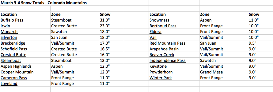
March 3-4, 2012 Storm Snow Totals
On Wednesday, the real warm-up begins for the Front Range cities, with low temperatures in the city starting out in the low 20's, but rising into the lower 60's by the afternoon. Temperatures will reach the low 60's on Thursday as well. Ahead of the next system, highs will be a tad cooler on Friday as clouds start to move in, but still mild. After a few days of quiet weather, big changes are on the horizon for this weekend...
Front Range snowstorm still on track for Saturday, but timing, duration, and amounts are still uncertain
Models are still indicating a good snowstorm for the Front Range, but are trending toward a faster-moving storm, which would favor less accumulations than originally anticipated (the models were initially favoring a slow-moving storm). However, nothing is certain yet as we are still 3-4 days away from this event, so small changes in speed and storm track are still possible. Even with a quicker-moving storm, significant totals are still a strong possibility. As we move closer to the event, details will come into focus, but for now, expect the brunt of the storm to hit on Saturday, lasting into at least Sunday morning... initial focus will actually be in the San Juan Range, where heavy snow will be possible Friday night, before shifting toward the Front Range.

No comments:
Post a Comment